Subject: Asia
Period: 1659 (circa)
Publication: Les Etats, Empire, Royaumes ... du Monde
Color: Hand Color
Size:
21.7 x 16 inches
55.1 x 40.6 cm
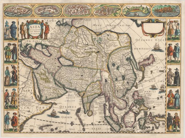
This is a scarce derivative of Jodocus Hondius' superb map that was first issued in 1623 in response to fierce competition with the Blaeu family, whose own carte-a-figures map of Asia was published in 1617. Nicolas Picart copied Hondius' carte-a-figures maps of the continents, maintaining Hondius' imprint within the titles, but adding his own imprint in a secondary cartouche. Picart's maps are close copies of Hondius' editions, but can be identified by a stylistic difference in lettering as well as other minor changes. A second state of Picart's maps were created for publication in Pierre d'Avity's Les Etats, Empire, Royaumes ... du Monde (1659), for which Picart's imprint was erased from the secondary cartouche, as evidenced on this example.
Cartographically, the map conforms to the Blaeu model in most respects, except in the delineation of the northeastern coastline of Asia, which does not extend in to the Arctic. The map extends from the Arabian peninsula through the East Indies. There is a wide expanse of ocean between the east coast of Asia and America, which is conveniently hidden by a cartouche, which is blank in this edition. Korea is shown as a long peninsula and Japan is based on the Ortelius/Teixeira model. The upper border features town plans of the eastern Mediterranean and Middle East and at sides are panels showing various costumes of people throughout the continent. Two hunters flank the title cartouche and the sheet is embellished with European ships, a Chinese sampan and a sea monster. All editions of the carte-a-figures version of this map are rare because a new smaller map without the borders, prepared by Henricus Hondius and Jan Jansson in 1631, replaced this map in most editions of the Mercator/Hondius atlases. Picart's editions are even rarer. Blank verso.
References: cf. Van der Krogt (Vol. I) #8000:1C.1; cf. Yeo #25.
Condition: B+
A superb, dark impression on a bright sheet, issued folding and now flattened with professional repairs to some separations along the folds and to a long tear at left that extends to the Caspian Sea and is now nearly invisible. Professionally remargined at right, bottom, and partially at left.