Subject: Texas & Mexico Border, Rio Grande
Period: 1854 (dated)
Publication:
Color: Black & White
Size:
14.4 x 13.6 inches
36.6 x 34.5 cm
The Office of Coast Survey is the oldest U.S. scientific organization, dating from 1807 when Congress directed that a "survey of the coast" be carried out. By 1836, it was called the U.S. Coast Survey and in 1878, the name was changed to the U.S. Coast and Geodetic Survey. Today the Office of Coast Survey is a division of the National Oceanic and Atmospheric Administration NOAA.
The survey teams, composed of civilians as well as Army and Naval officers, charted the nation's waterways and produced a wide array of reports, survey charts, hydrographic studies of tides and currents, astronomical studies and observations, and coastal pilots. These charts are an important record of the changing nature of the nation's coastlines. In additional to coastal charts, the U.S. Coast and Geodetic Survey produced land sketches, Civil War battle maps, and the early aeronautical charts.
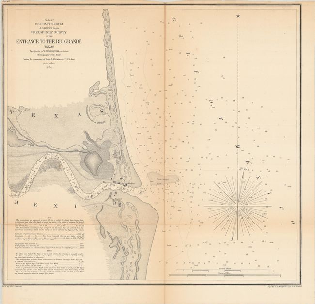
This represents the only USCS charting of the area. It provides a detailed view of the first few miles of this great river. At the mouth of the river is the village of Bagdad, and an observatory is located on the opposite shore. There is nice topographical detail and many soundings given, including in the Rio Grande itself. Drawn by W.E. Greenwell and engraved by C.A. Knight and F.W. Benner.
References:
Condition: B
Issued folding with light toning along the folds and a 3" fold separation at top that has been closed on verso with archival tape. The margin has been trimmed close to the neatline at left.