Subject: Southwestern United States & Mexico
Period: 1850-53 (circa)
Publication:
Color: Hand Color
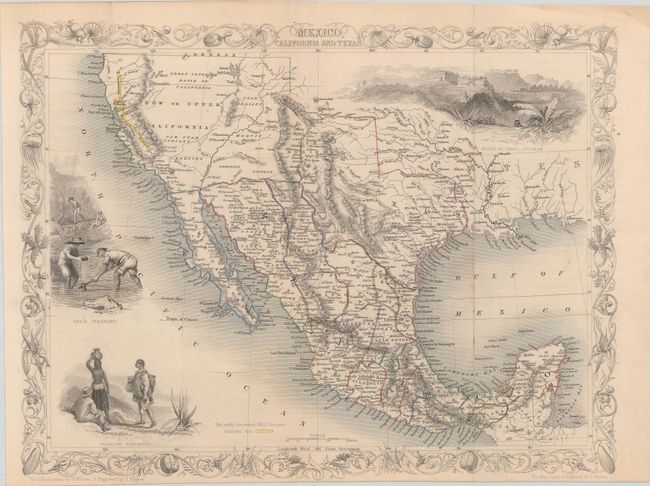
A. Mexico, California and Texas, by John Tallis, circa 1850 (12.9 x 9.9"). This is the second, and most desirable, state of this fine steel-engraved map that was issued during a time of great transition in the region. After gold was discovered in California, the plate was re-engraved to include a vignette of gold panning and to locate the gold regions of California, which are delineated through hand coloring. Texas is shown with its original state borders that include much of present-day New Mexico and extend into Colorado. Two other vignettes show Mexican peasantry and the ancient Mayan ruins at Uxmal. The very decorative border incorporates native plants of the region. Map drawn and engraved by John Rapkin, vignettes drawn by H. Warren and engraved by J. Rogers. Condition: Original outline color with a hint of toning along the fold lines and sheet edges. Issued folding and trimmed to the decorative border at bottom by the binder. (B+)
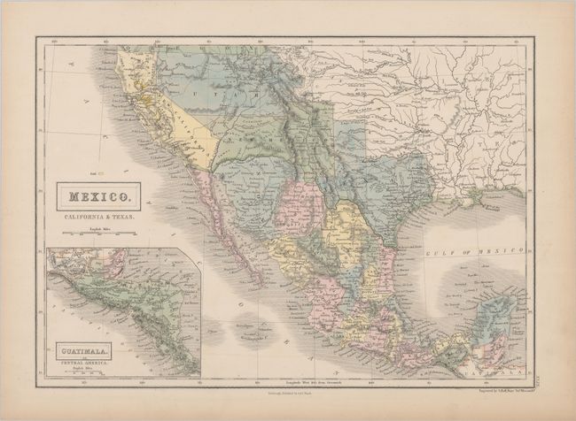
B. Mexico, California & Texas, by Adam & Charles Black, circa 1853 (14.5 x 10.3"). This delicately engraved map depicts Mexico and the region recently acquired by the United States in the Mexican/American War. The map features a pre-Gadsden Purchase border between Mexico and the United States. California is still labeled as Upper or New California, but the border clearly matches California's boundaries as we know them. This map is likely from California's military government status prior to achieving Statehood in 1850. The rivers of the Gold Region are well shown and hand colored in yellow. There is good detail of the Californian missions and early forts throughout the Southwest. The huge Utah Territory stretches between California and Indian Territory, and Texas is oversized and misshapen, but gives extensive early information. Numerous Indian Tribes are also located, including the Moquis, Apaches, Pima, Utes and more. An inset map of Central America is featured in the Pacific, entitled "Guatimala or Central America." Engraved by Sidney Hall. Condition: Contemporary color with a hint of toning along the sheet edges. (A)
References:
Condition:
See description above.