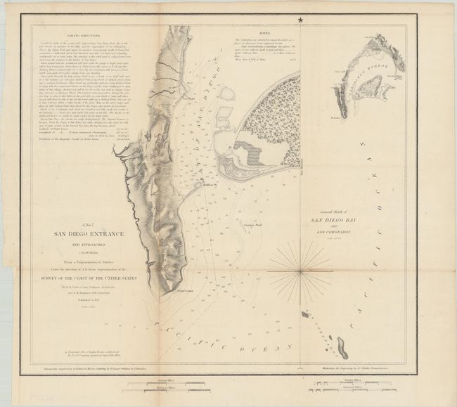
Subject: San Diego, California
Period: 1851 (dated)
Publication:
Color: Black & White
Size:
12.9 x 11.8 inches
32.8 x 30 cm
The Office of Coast Survey is the oldest U.S. scientific organization, dating from 1807 when Congress directed that a "survey of the coast" be carried out. By 1836, it was called the U.S. Coast Survey and in 1878, the name was changed to the U.S. Coast and Geodetic Survey. Today the Office of Coast Survey is a division of the National Oceanic and Atmospheric Administration NOAA.
The survey teams, composed of civilians as well as Army and Naval officers, charted the nation's waterways and produced a wide array of reports, survey charts, hydrographic studies of tides and currents, astronomical studies and observations, and coastal pilots. These charts are an important record of the changing nature of the nation's coastlines. In additional to coastal charts, the U.S. Coast and Geodetic Survey produced land sketches, Civil War battle maps, and the early aeronautical charts.
An important, early San Diego nautical chart. Two-thirds of the plate is taken up by a chart of Point Loma and part of North Island; the remainder is a sketch chart of the entire Bay plus approaches from as far south as the Coronado Islands. Sailing directions, light houses, soundings, and topographical features are illustrated and noted.
References: Guthorn, pp. 186-87.
Condition: B+
Issued folding and now flattened and backed with tissue. There is light toning along the fold lines.