Subject: United States, Railroads
Period: 1878-87 (circa)
Publication:
Color: Printed Color
This lot features three maps involved in the controversy over the U.S. grants of land to subsidize railroad construction:
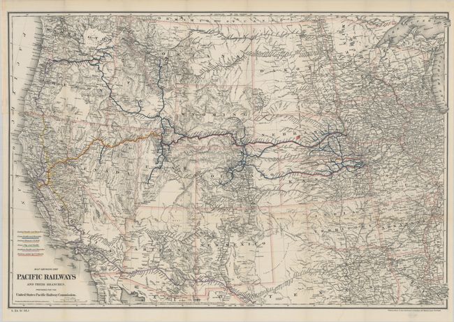
A. Map Showing the Pacific Railways and Their Branches Prepared for the United States Pacific Railway Commission, by G.W. & C.B. Colton & Co., dated 1887 (33.1 x 22.4"). This map of the western United States shows topography, drainage, cities and towns, and the extensive railroad network that existed west of the Mississippi. The network is colored-coded to show the Union Pacific, Central Pacific, Central Branch U.P.R.R., Sioux City and Pacific, Southern Pacific, and 'Portions Aided by U.S. Bonds'. This map shows the network at a time of rapid growth and prior to the business depression of 1893 that resulted in bankruptcy and reorganization of the Union Pacific Railroad Company. Condition: A clean bright example with a few tiny splits at the fold junctions and a short binding tear at left that has been closed on verso with archival tape. (A)
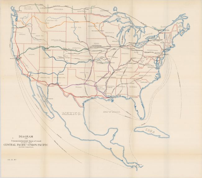
B. Diagram of the Transcontinental Lines of Road Showing the Original Central Pacific and Union Pacific and Their Competitors, U.S. Government, circa 1887 (19.5 x 18.5"). This map accompanied the previous map in the Pacific Railway Commission's voluminous report on the U.S. Government’s subsidies of the railroads that had become a political issue in the 1884 Presidential election. It displays the major railroads with colored lines and finely engraved text. The presumed competitors are shown via small black lines, also labeled with the name. The Canadian Pacific R.R. is detailed in southern Canada, and one line is shown to Guaymas, Mexico from Benson, Arizona Territory. Sea routes are also depicted and named including the Morgan Line and Clipper Ships route around Cape Horn. Condition: There is a hint of toning, otherwise fine. (A)
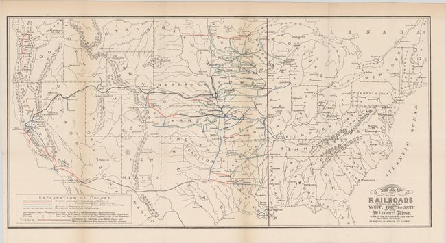
C. Map of the Railroads in Whole or in Part West, North or South of the Missouri River to Which the United States Have Granted Any Loan of Credit or Subsidy in Bonds or Lands, by U.S. Department of Interior, circa 1878 (23.9 x 12.0"). This map shows the railroad lines west of the Missouri River that had received some form of assistance from the United States government. Assistance took the form of bond issuance and land subsidies, with the bulk being land grants. This example was part of the original publication from the Annual Report of the Secretary of the Interior 1878 and precedes Donaldson’s use of it in his 1883 report that triggered the 1884 election issue. Condition: Light toning along the fold lines. (B+)
References:
Condition:
Issued folding. See description above for details.