Subject: North Pole
Period: 1790 (circa)
Publication:
Color: Hand Color
Size:
18.4 x 18.3 inches
46.7 x 46.5 cm
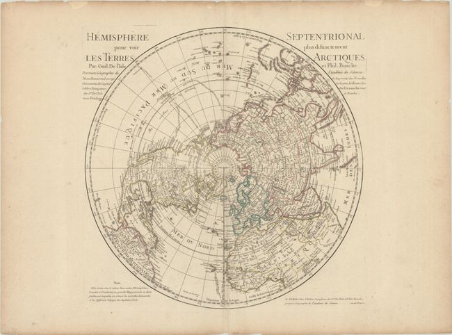
This is a Buache/Dezauche issue of this important map, originally produced by Guillaume Delisle in 1714. Delisle's map was the first map to correctly place the west coast of North America by moving it east substantially from previous mapping. The map went through several revisions; this issue delineates the tracks of Cook's voyages and includes up-to-date information from his third voyage (1776-80). As a result, Hawaii now appears on the map and Alaska and the northwestern coast of North America are more accurately depicted. Captain Cook's death is noted in Hawaii. California is correctly shown as a peninsula, although a dotted line still hints at the possibility of the island form. A large portion of northwestern Canada is blank and labeled l'Interieur de ce Pays est Inconnu. There is a curious note about the discovery of the fabled River of the West by the Spanish in 1063 and a short conjectural course of the river between Sioux country and Quivira. There is no sign of Mer de l'Ouest, Terre de la Compagnie, or the fictional lakes Velasco and Fonte that appeared on previous editions. Above Japan, the Isle du Ieso (Hokkaido) is shown with an uncertain coastline. The first Buache/Delisle issue was dated 1782; this is a later, undated issue published circa 1790, perhaps the last edition of this landmark map.
References: cf. Wagner #504.
Condition: B+
A nice impression on a sheet with a large watermark of a Maltese cross encircled in rosary beads. There are a few small holes in the map image, an extraneous crease running along the centerfold at bottom, and marginal toning and soiling.