Subject: Arizona
Period: 1895 (dated)
Publication:
Color: Printed Color
Size:
35.6 x 27 inches
90.4 x 68.6 cm
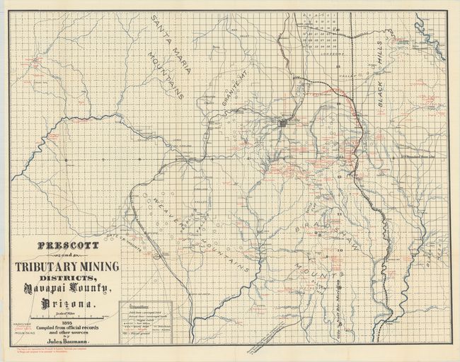
A fabulous mining map centered on the region around Prescott, Arizona, in 1895. Gold discoveries in Yavapai County date back to two expeditions in 1862-63 led by Pauline Weaver and Joseph Walker, who had traveled extensively as trappers in the region some fifteen or twenty years earlier. These discoveries had some bearing on the establishment of Arizona Territory in 1863 and Prescott becoming the capital in 1864. The map locates scores of mines, ranches, school houses, towns, railroads, roads, and post offices. The mines are named, located by a small "x," and printed in red. The numerous rivers and streams are well shown with blue overprinting. The Prescott & Eastern Railroad, now completed to Mayer, is shown with red overprinting. Numerous rail lines are delineated and named including the narrow gauge line to Jerome that extends from the Verde Junction and crosses Mingus Mountain. There is good detail of Jerome including the smelter. The Santa Fe, Prescott & Phoenix Railway is clearly shown. The Prescott and Arizona Central R.R. line extending north from Prescott appears to be cancelled through red overprinting. Another line extending from below the margin to Hot Springs is noted as a proposed railroad to connect with the Santa Fe, Prescott & Phoenix Ry.
References:
Condition: A
Issued folding with a couple fold splits repaired with archival tape on verso.