Subject: Arizona
Period: 1854-55 (dated)
Publication: U.S. Pacific Railroad Surveys
Color: Black & White
Size:
38.5 x 23.8 inches
97.8 x 60.5 cm
During the 1850s, the U.S. government sponsored an extensive series of expeditions designed to gather information on the vast new territories that had been acquired in western North America. The discovery of gold in California further stimulated westward traffic and heightened the need for a faster and more convenient way to bring the far-flung parts of the country together. In 1853 Congress commissioned the Army's Topographic Bureau to conduct a series of surveys to find a suitable route for a transcontinental railroad. There were six major expeditions; five of them covered the area between the Great Plains and west coast, and the sixth explored the coastal states of California and Oregon. All of these expeditions were accompanied by naturalists and artists to document the landscape, flora and fauna along the route.
The reports, maps and lithographs were published in the 13 volume report "Explorations and Surveys to ascertain the most practicable and economical route for a Railroad from the Mississippi river to the Pacific Ocean."
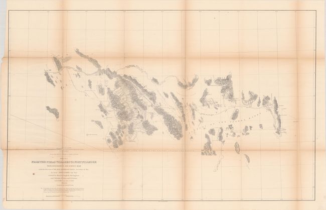
This well-engraved map covers the vicinity of the Gadsen Purchase, acquired by the United States in 1853 to facilitate a southern railway that skirted mountain ranges. The map extends from the Pima and Maricopa Villages along the Rio Gila east to Fort Bliss and El Paso del Norte. The proposed railroad is shown snaking along south of the Gila River before dipping southeast to cut through Rail Road Pass and proceed past Pyramid Peak, through Florida Pass, and on to Fort Bliss. As Wheat notes, "This was a practicable route but the Southern Pacific found a better one farther south." Topography is depicted through fine hachure. In addition to various mountains, rivers, and springs, the map notes Cooke's Emigrant Route, Major Emory's course in 1846, and various settlements, forts, and mines. Parke conducted the first survey of the area and published another map of the region, Route of a Survey from the Pimas Villages on the Rio-Gila to Mesilla on the Rio-Bravo-del-Norte... (1854), before this one.
References: Wheat (TMW) #851.
Condition: B
There is light toning along the folds and several fold separations that have been closed with archival materials on verso. Modern binding is fine.