Catalog Archive
Auction 180, Lot 193

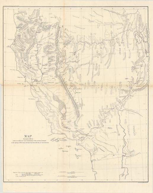
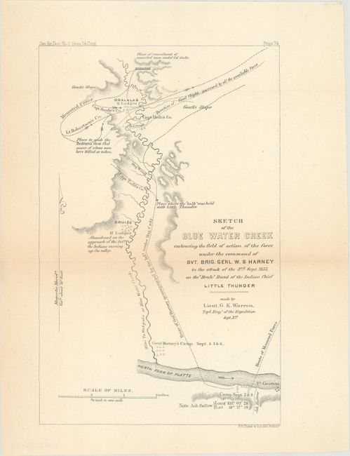
"[2 Maps with Report] Map Showing the Different Routes Travelled Over ... from Salt Lake City, Utah to the Bay of San Francisco [with] Message from the President of the United States ... the Thirty-Fourth Congress [and] Sketch of the Blue Water Creek... ", U.S. Government

Subject: Western United States

Period: 1855 (published)

Publication:

Color: Black & White

Size:
5.9 x 9.2 inches
15 x 23.4 cm
Download High Resolution Image
(or just click on image to launch the Zoom viewer)

A. Map Showing the Different Routes Travelled Over by the Detachments of the Overland Command in the Spring of 1855 from Salt Lake City, Utah to the Bay of San Francisco [with report] (18.7 x 22.2"). Wheat describes this map as "a document of first quality ….. showing three important routes." Steptoe was looking for a new and shorter route from the Great Salt Lake to the Pacific Coast. In addition to the route chosen by Steptoe, the routes of two detachments are also traced - one under Capt. Ingalls, the other by Lt. Mowry. The map extends to include all of California and part of Oregon to above the Rogue River. It stretches eastward to name G.S. Lake City, the Mormon capital of Fillmore, Cedar City and Fort Yuma on the Colorado. Although published separately, it is accompanied here by the report it documents: “Reports by Captain Rufus Ingalls on the march from Fort Leavenworth to Salt Lake City, and from that place to San Francisco Bay” (pages 152-168). In two letters Ingalls gives reports of Steptoe’s overland expedition and the alternate route to California taken through the Rogue River Valley by a detachment that included Ingalls. Ingalls provides good detail on the routes, the remnants of the struggles of previous travelers, and his outrage that the Indians who murdered Capt. John Gunnison (of the Pacific Railroad Survey) were convicted only of manslaughter and then allowed to escape. He blamed the Mormon government for tampering with the jury and called for separation of church and state in the territory.

The volume also contains the report of Gen. Wm. S. Harney who led the Sioux Expedition of 1855 against the Lakota Sioux that culminated in the Battle of Ash Hollow, also known as the Harney Massacre in which many of the 86 Sioux killed were women and children (not mentioned here in Harney’s report). The massacre initiated a series of revenge killings and massacres in the west. One Sioux boy who legend says was a survivor (or certainly affected by the loss of relatives) went on to take his own revenge at the Battle of Little Big Horn. Crazy Horse became a Sioux war chief and was instrumental in Custer’s defeat. 574 pages. Octavo, hardbound in brown cloth with gilt title on spine. Condition: The folding map is in much better condition than normally seen with some faint scattered foxing. Text is mostly clean and bright with occasional foxing or minor toning. Binding has only minor shelf wear. (A)

B. Sketch of the Blue Water Creek Embracing the Field of Action of the Force Under the Command of Bvt. Brig. Genl. W. S. Harney…, by Lieut. G. K. Warren (5.6 x 8.7"). Separately issued from the above, this small map shows the region near present-day Ash Hollow, the site of one of the first major battles in the Indian Wars. It shows the camp of the Brule band of the Ogallala Sioux, led by Chief Little Thunder, and their flight from the army of 600 soldiers led by Col. William. S. Harney. Detailed movements are shown for the infantry and cavalry. For Warren’s detailed report on the horror of the battle, click here. Condition: Issued folding with light toning along the center fold line. (B+)

References: Wheat (TMW) #868; Wagner & Camp #256 & #283.

Condition:

See description above.

Estimate: $200 - $230

Sold for: $120

Closed on 11/18/2020

Archived