Subject: Atlases
Period: 1618 (published)
Publication:
Color: Black & White
Size:
7.5 x 5 inches
19.1 x 12.7 cm
This handsome atlas is a revised version of Barent Langenes' Caert-Thresoor with French text by Petrus Bertius and new maps by Jodocus Hondius. It is nearly complete with 219 of the 220 called for maps, missing only the map of Europe (this appears to be a binder's error as there is no evidence of the map being removed). The atlas is divided into seven sections including: World (5 maps); North Polar (6); Southern Continent (3); Europe (150 of 151); Africa (15); Asia (27); and America (13). The atlas is unusual in that it contains two examples of the double-hemisphere world map, Typus Orbis Terrarum, on both page 8 and page 36 (matches collation with Van der Krogt). There are numerous plates of interest in this atlas including the following:
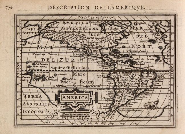
America. This handsome map of the Americas is based on the 1606 map by Jodocus Hondius senior, but with the addition of the recent discovery of Hudson Bay. This small map marks the first appearance of Hudson Bay on a continental map, named here as Fretum Hudsonium. North America is shown with a large westward bulge, and the continent is filled with place names. The western coast has more names than the eastern coast, including Anian, Quivira, Tolm, Chuchuco and many others. Virginia, Florida, Chesepiook and St. Augustine are the only names on the East Coast. South America features the fictitious lake on the Equator, with the city of Manoa above, and the southern tip of the continent is nearly joined with the large, mythical southern continent of Terra Australis Incognita. New Guinea is shown attached to this large continent, and a portion of Japan and Asia appear above. The map is graced with an elaborate strapwork cartouche that incorporates the distance scale, and a whiskered sea monster swims off the coast of South America. Reference: Burden #183.
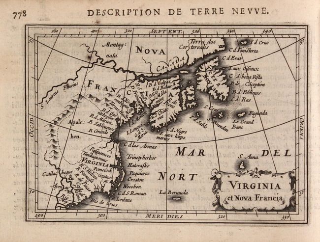
Virginia et Nova Francia. This charming map depicts the east coast of North America from the Rio May to Newfoundland. The map is based on Hondius' world map from 1611, but does not incorporate new information from the explorations of Samuel de Champlain (in Canada and along the Great Lakes) or of John Smith (in the Chesapeake Bay area and New England). The area from present-day New York to Maine is labeled Norenbega, and the area further south is labeled Virginia, with the Chesapeake Bay noticeably missing. A region just east of a large mountain range (the Appalachian mountains) is named Apalc: hen, and the St. Lawrence river is featured prominently at top. Several small islands grace the Atlantic, including La Bermuda and S. Anna. References: Burden #185; Cumming #31; Kershaw #51.
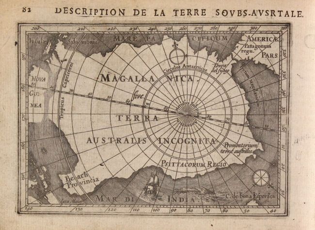
Description de la Terre Soubs-Australe. This significant map is one of the first to focus solely on the South Pole. It depicts a large Magallanica Sive Terra Australis Incognita incorporating Terra del Fuogo, Beach Provincia, Psittacorum Regio, and Promontorium Terrae Australis. The large landmass is separated from South America by the Strait of Magellan, and almost joined to Nova Guinea, with the Salomon Islands depicted nearby. The map is handsomely adorned with a fierce sea monster, a sailing ship, and two compass roses orienting north away from the South Pole. Reference: Tooley (MCC-2) #12.
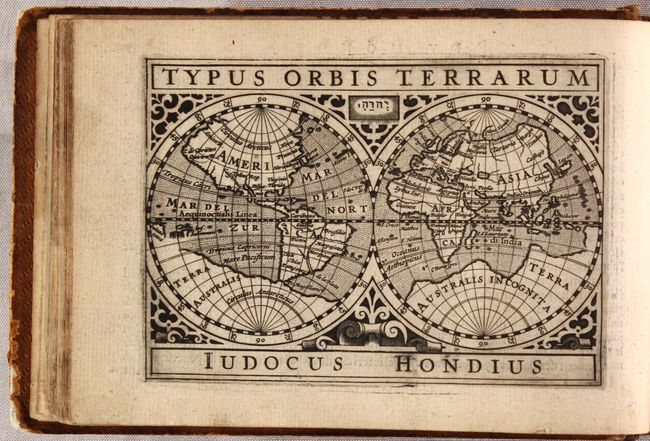
Typus Orbis Terrarum. This is Bertius' second miniature world map. It is a double hemisphere based on Mercator's famous world map with several updates by Jodocus Hondius. Terra Australis Incognita fills the Southern Hemisphere and connects to New Guinea in the region of Australia. Mercator's Northwest Passage and interesting polar islands have been replaced with a non-descript landmass. The eastern coast of Asia has been revised to include a Korean Peninsula. The map is richly decorated in a strapwork surround with the cartographer's name boldly engraved below the map. Reference: Shirley #291.
Hondius' plates were well received and used in later publications including Paullus Merula's Cosmographia Generalis, Cloppenburch's Wereld Spiegel, and Joan Blaeu's Atlas Minor. Oblong octavo. French text, 829 pages. Hardbound in full leather with gilt tooling and title label on spine.
References: Shirley (BL Atlases) T.BERT-2b; Van der Krogt (Vol. III) #342:01; King (2nd ed.) pp. 96-99.
Condition: B+
Strong dark impressions on mostly clean sheets with occasional soiling. There is a faint dampstain along the left border of the Holland map, and small repaired chips along the top border of two regional maps of Germany and Austria. The bottom margin of the title page has been extended, and several chips to the tables at the end of the volume have been reinstated with old paper. The hinges are starting and there is a previous owner's bookplate on the front pastedown. Binding is moderately worn with bumped edges and chips to the head and tail of the spine.