Catalog Archive
Auction 179, Lot 697

"Iudaea seu Palaestina ob Sacratissima Redemtoris Vestigia Hodie Dicta Terra Sancta Prout olim in Duodecim Tribus Divisa Separatis ab Invicem Regnis Iuda et Israel...", Homann, Johann Baptist
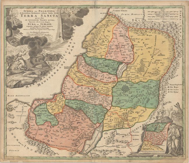
Subject: Holy Land

Period: 1720 (circa)

Publication:

Color: Hand Color

Size:
22.6 x 19.3 inches
57.4 x 49 cm
Download High Resolution Image
(or just click on image to launch the Zoom viewer)

Homann based this map of the Holy Land on the cartography of Guillaume Sanson. It presents the region divided among the twelve tribes of Israel and covers from Sidon to Sirbonis L in the Egyptian desert. The Kishon River is shown as connecting the Mediterranean Sea with the Sea of Galilea. The dramatic title cartouche features Moses receiving the Ten Commandments and inset in the opposite corner is a map showing the Exodus and Wandering surrounded by a finely engraved scene including Moses, Aaron, and the two spies of Moses bearing a huge bunch of grapes.

References: Laor #340.

Condition: B+

Full contemporary color with light soiling and a few small abrasions. Pasted onto another sheet to repair several tears adjacent to the centerfold and chips in the bottom blank margin.

Estimate: $275 - $350

Sold for: $200

Closed on 9/16/2020

Archived