Subject: Middle East
Period: 1625 (circa)
Publication:
Color: Hand Color
Size:
19.4 x 11.4 inches
49.3 x 29 cm
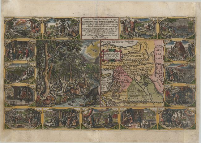
This supremely graphic map is from the second series of Dutch bible maps by Petrus Plancius, first published in 1604 by Johannes Cloppenburg. The first series consisted of a world map and 4 small maps of the Holy Land and Middle East, engraved by Johannes van Deutecum and his two sons, Johannes and Baptista. After Johannes van Deutecum (the younger) published a new set of maps in 1595, Plancius realized that his own maps required updating. He commissioned Baptista van Deutecum to engrave the second series, who also enlisted the assistance of engravers Daniel van Bremden and Pieter Bast. Plancius' second series retained the same world map and 6 larger, re-engraved maps of the Holy Land and Middle East. The purpose of the maps was to help explain the biblical texts, but Plancius decided to take the maps one step further by adding 15 biblical vignettes surrounding each map, thereby transforming each map into a work of art.
This map features a large engraving of Adam and Eve in the Garden of Eden, surrounded by a variety of animals and birds. The scene is juxtaposed beside the map locating Paradisus just south of Babylon. The sheet is then further embellished with fifteen oval vignettes from Genesis. Engraved by Baptista van Doetichum, with the large Garden of Eden vignette engraved by Daniel van Bremden. This is the second state, with the imprint of D.R. M. Mathes replacing that of Plancius. Dutch text on verso.
References: Laor #565; Poortman & Augusteijn #73.
Condition: B
A dark impression on a bright sheet with archival repairs to a centerfold separation at bottom and several short tears. The right and left edges of the sheet have been professionally replaced, with a strip of the border skillfully and seamlessly replaced in facsimile on each side. At left the facsimile work extends into the bottom two vignettes between 1/4" and 1". At right the facsimile work extends 1/4" into the top two vignettes, and 1.25" into the bottom three vignettes. The map presents itself beautifully as a result of the excellent facsimile work.