Subject: Eastern United States
Period: 1798 (dated)
Publication: Nuovo Atlante Geografico Universale
Color: Hand Color
Size:
18.8 x 13.6 inches
47.8 x 34.5 cm
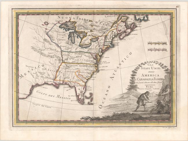
This lovely Italian map of the young United States was mainly derived from Zatta's copy of Mitchell's map of North America. The map presents the Florida peninsula as an archipelago. Georgia is just a narrow strip of land in the Carolinas located between the Savannah and Giorgio rivers. The Carolinas, Virginia, and Pennsylvania all stretch to the Mississippi River. Western New York is depicted as part of a massive Pennsylvania. The Luigiana Territory is identified. In present-day Texas, some towns are named, including Texas (along a Colorado River that runs into the Gulf of Mexico), Cenis, and Toos. There is nice detail of the Great Lakes. Numerous tribes are located. The large title cartouche at bottom right features a vignette of natives in the middle of a hunt.
References: Phillips (Atlases) #670 Vol. III #23; Portinaro & Knirsch #CLXIII.
Condition: A
A crisp impression with contemporary color. There is some printer's ink residue, very faint offsetting, a hint of toning along the centerfold, and a tiny tear in the top blank margin.