Subject: United States, Texas
Period: 1842 (circa)
Publication: Smiley's Atlas
Color: Hand Color
Size:
17 x 10.6 inches
43.2 x 26.9 cm
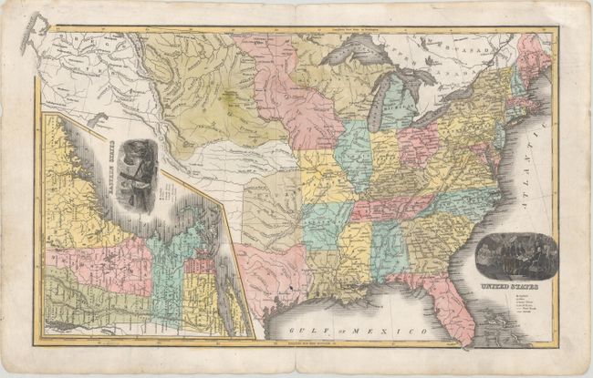
This uncommon school atlas map of the United States shows the interesting territorial developments of the era. The map depicts the Republic of Texas in its smaller configuration along the Red and Nueces rivers, with a Western Territory to its north. Wisconsin Territory includes parts of present-day Minnesota and Michigan's Upper Peninsula. Iowa Territory extends along the Missouri River to the Canadian border. In between the Missouri River and the Rockies, there is a vast Missouri Territory. Oregon Territory is named in the Northwest, but California and the Southwest are obscured by a large inset titled Eastern States that zooms in on New England. The map includes two vignettes: one showing the signing of the Declaration of Independence, the other symbols of "commerce, manufacture, and agriculture." Engraved by E.F. Woodward. According to David Rumsey, "Tanner supposedly had a part in making this atlas."
References:
Condition: B+
A short centerfold separation at bottom and a 0.5" tear across the centerfold have both been repaired with archival materials on verso. There is a small spot in the Declaration of Independence vignette, a printer's crease at right, and light soiling that is mostly confined to the blank margins.