Subject: Russia in Asia
Period: 1652-1780 (circa)
Publication:
Color:
A nice set of maps showing the Russian Empire spanning more than a century:
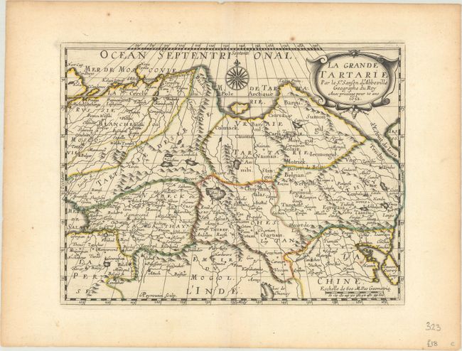
A. La Grande Tartarie, by Nicolas Sanson, dated 1652, hand color (10.0 x 7.6"). Attractive map of Siberia, northern China, and Korea, which is shown here as an island. The cities, mountains, forests and rivers are well-detailed. Siberia still reflects some of Ptolemy’s conceptions with the Island of Tazata and the Cape of Tabin in the extreme north. The map is decorated with a lovely title cartouche as well as a beautiful compass rose. Engraved by Peyrounin. Condition: Contemporary outline color on watermarked paper with a few spots of foxing in the top blank margin. (A)
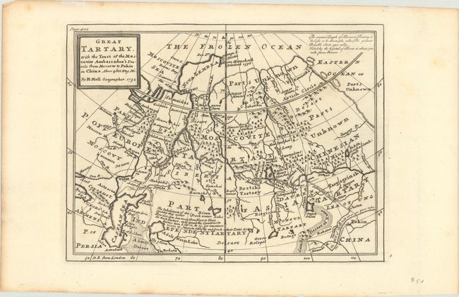
B. Great Tartary. With the Tract of the Moscovite Ambassador's Travels from Moscow to Pekin in China. Above 4600 Eng. Mi., by Herman Moll, dated 1732, black & white (10.4 x 7.8"). This map of Russia shows the path of a Russian Ambassador who traveled from Moscow to Beijing. Interesting notations concerning the land and its people are provided, including one describing a nomadic group that neither "plow nor sow, but move from place to place." Condition: A dark impression on a bright sheet of watermarked paper. (A)
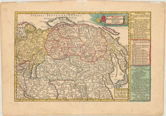
C. Das Gantze Russische Kaeyserthum mit Allen Seinen Laendern, by Johann Georg Schreiber, circa 1749, hand color (9.8 x 6.4"). This densely engraved small map details the area between Finland, Russia, Novaya Zemyla, Northern China, Japan and the Persian Gulf. It is filled with pictorial representations of forests, mountains, tent encampments, and an illustration of the Great Wall of China. A pair of ships sail in the Sea of Japan, and named above Japan itself is a wildly misshapen Terra Jedso (Hokkaido). The title cartouche is flanked with figures representing European and Asian men. Condition: Light toning and minor foxing. (B+)
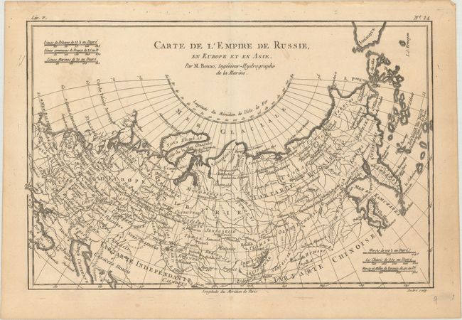
D. Carte de l'Empire de Russie, en Europe et en Asie, by Rigobert Bonne, circa 1780, black & white (12.8 x 8.3"). This map covers the entire Russian Empire stretching from the Baltic Sea to the Bering Sea in the north and from the Black Sea to the Sea of Okhotsk. The northwestern tip of North America is labeled Amerique and the island of Alaschka lies between Russia and America. Condition: Light toning mostly along the sheet edges and faint offsetting. (B+)
References:
Condition:
See description above.