Subject: Southern Hemisphere
Period: 1774 (circa)
Publication: Abrege de l'Histoire Generale des Voyages
Color: Hand Color
Size:
21.2 x 21.1 inches
53.8 x 53.6 cm
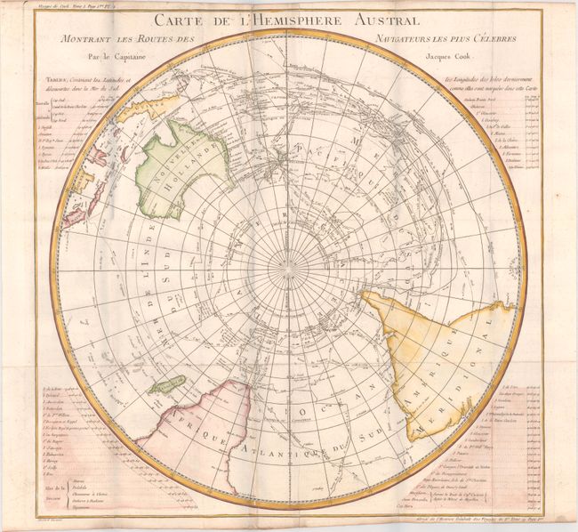
Captain James Cook (1728-1779) is best known for his three voyages to the Pacific (1768-71; 1772-75; and 1776-79). His discoveries radically changed the western understanding of the world in the late 18th century. He was the first to circumnavigate and chart New Zealand and provided the earliest European accounts of exploration along the eastern coast of Australia and the Hawaiian Islands. On February 14th, 1779, he was killed on Hawaii after attempting to kidnap the chief of the island.
Many contemporary accounts of Cook’s voyages, including charts and engravings, appeared in the late 18th century. The first official account of Cook’s first voyage was published in 1773 by John Hawkesworth in Volumes II and III of An Account of the Voyages Undertaken by the Order of His Present Majesty for Making Discoveries in the Southern Hemisphere... William Strahan and Thomas Cadell published the first official accounts of the second and third voyages in 1777 and 1784. Accounts of his exploration were subsequently translated into French, German, and Dutch.
This uncommon chart is a French edition of Cook's voyage in the southern hemisphere that is drawn in a circular polar-projection. Lists beside the map provide details of discoveries and destinations in the southern hemisphere. The chart includes the routes of other explorers including Tasman, Dampierre, Carteret, Byron, Bougainville, Furneaux and others. The copper-engraved chart shows all of Australia (Nouvelle Hollande) with Tasmania attached to the mainland. There is good detail of the East Indies and the Celebes. An important chart for any collector of Antarctic material.
References:
Condition: B+
A crisp impression on a bright sheet with the watermark of a Maltese cross encircled in rosary beads, issued folding. There is faint offsetting and some extraneous creasing of the paper. The gray shadows in the image are caused by our scanner due to the heavy folds in the paper, and do not appear on the map itself, which is generally very clean and bright.