Subject: New York & Vermont
Period: 1951 (dated)
Publication:
Color: Printed Color
Size:
17.8 x 22.6 inches
45.2 x 57.4 cm
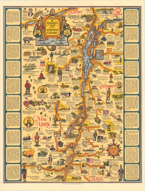
This is the revised edition of C. Eleanor Hall's pictorial map of the meeting point between Upstate New York, Vermont, and Canada. It spans from Albany north to Saint-Jean-sur-Richelieu. The landscape is filled with charming illustrations highlighting the history and culture of the region. Included among the illustrations are President James Monroe (noted here for founding the Plattsburgh-Sacketts Harbor); Champlain battling the Iroquois in 1609; the Defeat of the Black Watch; ice fishing; a scene from James Fenimore Cooper's The Last of the Mohicans; the discovery of Lake Champlain; President James A. Garfield (noted here for teaching in Pownal); and the home of Norman Rockwell in Arlington. The compass rose is a reproduction of the one used on Champlain's map of New France. A title cartouche at top left incorporates portraits of Champlain, Thomas Macdonough, John Burgoyne, Louis-Joseph de Montcalm, and Philip Schuyler. The map is bordered by columns of historical text at left and right. Hall was a Vermont-born librarian who paid $784.75 to print 10,000 copies of this map in the midst of the Great Depression. By 1950, she had sold out the original run, leading her to publish a revised edition of 3,000 copies the following year. Hornsby specifically cites the map as an example of "the part played by educated women in preserving and popularizing American local history." Printed by the Holling Press, Inc. of Buffalo, New York.
References: Hornsby (Picturing America) pp. 41-44 & plate 30.
Condition: A
Crisp and bright with minor creasing at bottom left.