Subject: Eastern United States & Canada, Franklinia
Period: 1799 (dated)
Publication: Travels Through the United States
Color: Hand Color
Size:
13.3 x 15.9 inches
33.8 x 40.4 cm
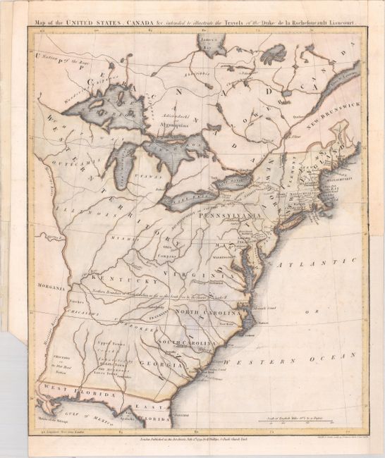
This very uncommon map depicts the nascent United States with several interesting and unusual features. In New England, Maine is shown with a truncated northern boundary, reflecting the British view of the border dispute. The Ohio Company land grant still appears north of the Ohio River, and Florida is divided between East and West. In the south, Georgia, South Carolina, and North Carolina all extend to the Mississippi River, with a note stating "Northern Boundary of North Carolina as far as the South Sea." Within North Carolina's boundary is the proposed state of Franklinia. In 1785 settlers in present-day western North Carolina and eastern Tennessee organized a state government to be named in honor of Benjamin Franklin. Congress turned down their appeal but the fledgling state maintained a legislature and governor until 1788. To the west of the Mississippi is Morgania. This region was named after George Morgan, a land speculator, who attempted to create a new colony in the then Spanish controlled Louisiana Territory near New Madrid (Morgan gave up this endeavor a few years later).
Beyond these fascinating boundaries and short-lived states, the original intent of the map was to show the travels of Francois Alexander Frederic La Rochefoucald Liancourt. A supporter of the French monarchy, La Rochefoucald Liancourt fled to England and then the United States during the French Revolution. He spent 3 years in exile in North America and published an account of his experience upon returning to France in 1799. His work (not included here) describes in detail the political constitution, natural history, physical geography, agriculture, and the customs of the inhabitants of the United States.
This is the second state of the map, engraved by Smith & Jones and published by R. Phillips.
References: Dotson & Baker (OWA) #14.2; Baynton-Williams #11; McCorkle #799.9; Sabin #39057.
Condition: B
Issued folding with minor foxing, a small dampstain along the right border, and a few short fold separations that have been closed on verso with archival tape. Remargined at left and right with a portion of the border drawn in facsimile.