Subject: North America
Period: 1850 (circa)
Publication:
Color: Hand Color
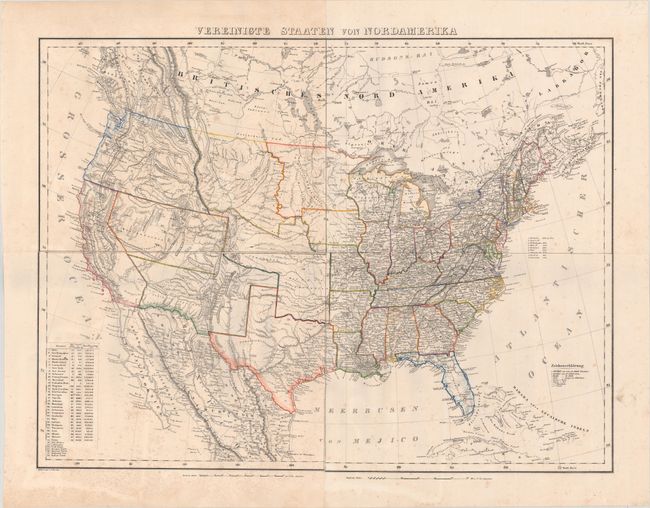
A. Vereinigte Staaten von Nordamerica (27.4 x 20.6"). This large, detailed map of the United States extends to include part of Canada and Mexico, although information is focused on the United States. The map provided an excellent view of the American West with some unusual territorial configurations. Texas has been updated to show its present-day borders, which results in a very odd looking Indian Territory and large New Mexico Territory. Missouri Territory takes up most of Montana and parts of Wyoming, while Oregon Territory incorporates Washington. The U.S.-Mexico border predates the Treaty of Guadalupe Hidalgo. The map depicts towns, missions, forts, railroads, and canals, and includes a list of the highest mountain peaks. A table lists the states and territories, with populations in 1840, number of counties, and size. Lithography by Handtke. Printed on four separate sheets, joined. Condition: Light scattered foxing.
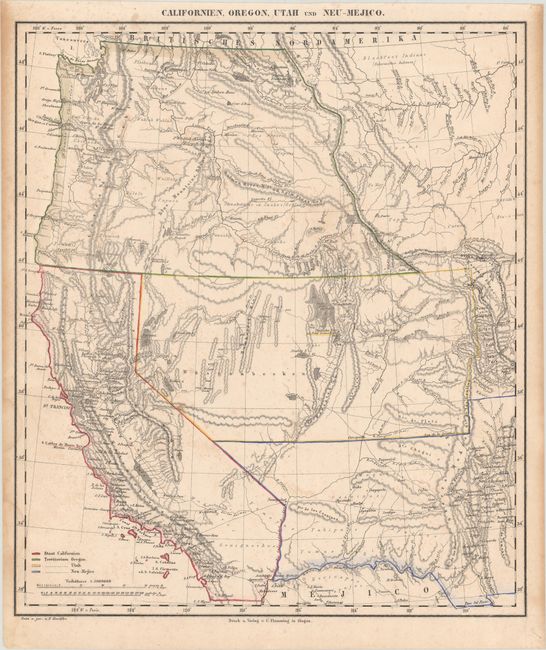
B. Californien, Oregon, Utah and Neu-Mejico (13.6 x 15.8"). Handsome map that depicts the state of California and the large western territories of Oregon, Utah and New Mexico. Oregon extends to the Canadian border, encompassing all of Washington. Salt Lake City is also named New Jerusalem. The border with Mexico is on the Gila River. Filled with Indian names, a few forts, and some interesting conjectural topography. Condition: Light scattered foxing with minor toning along the sheet edges.
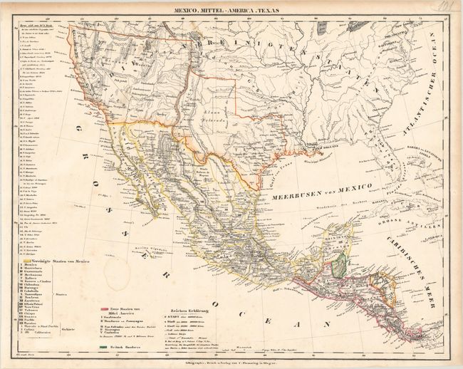
C. Mexico, Mittel-America, Texas (16.4 x 12.9"). Detailed map showing an evolving configuration in the Southwest. While the coloring does not reflect the engraved borders of the map, California had just become a state in 1850 and Texas is presented with its final, post-1850 borders. A notation (in German) in the panhandle of Texas shows the "summer range of the Comanches," while an early appearance of New Mexico Territory is shown to the east of the Sierra Madre. The map extends to include all of Central America with a color-coded key at bottom. Condition: There is faint foxing and a small dampstain in the Pacific Ocean.
References:
Condition: B+
Contemporary outline color. See description above for details.