Subject: Northwestern Africa, Niger River
Period: 1805 (circa)
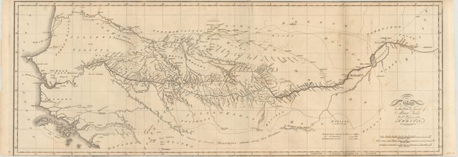
Publication: The Journal of a Mission to the Interior of Africa
Color: Hand Color
Size:
28.9 x 10.4 inches
73.4 x 26.4 cm
This map was issued in The Journal of a Mission to the Interior of Africa and shows the tracks of the Scottish explorer Mungo Park up the Niger River. Park first explored the region of the Upper Niger River in 1795 (marked in yellow outline) and subsequently wrote Travels in the Interior Districts of Africa where he theorized that the Niger and Congo rivers eventually merged. In 1805 he set out to prove this theory (marked in red outline), but was killed approximately two-thirds down the course of the river at Boussa. The Niger River mystery continued until 1830 when it was determined these were different river systems. Engraved by Josiah Neele. This was the only map included in Mungo's second account regarding the interior of Africa.
References:
Condition: B+
Issued folding with some light staining at right and a few minor edge tears at top that have been closed on verso with archival tape. Trimmed to the neatline at top and bottom, as issued.