Subject: Southeast United States
Period: 1785-1822 (circa)
Publication:
Color:
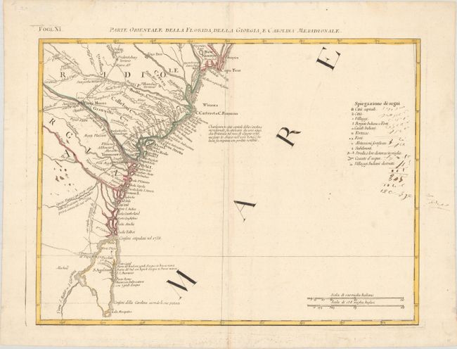
A. Parte Orientale della Florida, della Giorgia, e Carolina Meridionale, by Antonio Zatta, published in Atlante Novissimo, circa 1780, hand color (16.9 x 12.6"). This detailed map covers the coastline from Wilmington and Cape Fear to St. Augustine and Cape Canaveral. The map depicts cities, town, Indian villages, forts and roads and is especially noteworthy for naming early counties in South Carolina. An Italian notation concerning the British attack on Charleston in 1776 and a key to the map appears in the Atlantic. At this time Florida was still British, having been acquired from Spain in 1763. The map is sheet XI from Zatta's Le Colonie Unite dell' America Settentrle, which is often referred to as the Italian edition of John Mitchell's map, on which it is based. Zatta's maps retain Mitchell's scale, but being smaller are more legible. Zatta also included updated legends (in Italian) with notations concerning the Revolutionary War. Each sheet stands on its own and has full borders. References: Portinaro & Knirsch #153; Sellers and Van Ee #163; Shirley (BL Atlases) T.ZAT-1, Vol 4 #38. Condition: Contemporary color on a bright sheet with a three crescent moons watermark, a hint of toning along the centerfold, and old manuscript ink notations at far right and left.
B. Le Provincie Meridionali degli Stati Uniti, by Carlo Botta, published in Storia della Guerra dell'Independenza degli Stati Uniti, circa 1822, black & white (18.4 x 13.0"). A very uncommon Italian map covering the states of Kentucky, Virginia, Tennessee, North and South Carolina, and part of Georgia. It provides a good view of early settlements and roads, as well as the mountains, forests and Indian villages. Between Tennessee and Georgia is a long strip of land labeled Territorio degli Stati Uniti. This land originally belonged to South Carolina but was ceded back to the United States in 1787, subject to Indian occupancy. Numerous Indian villages are shown, especially in the region of present-day Alabama. References: Howes #B-636. Condition: A nice impression with light toning along the centerfold and a few minor spots.
References:
Condition: B+
See description above for details.