Subject: References, United States
Period: 1979-2011 (published)
Publication:
Color:
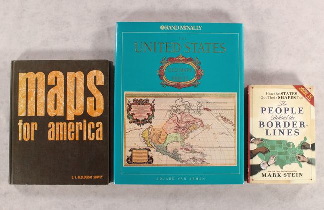
A. The United States in Old Maps and Prints, by Eduard Van Ermen, published 1990, printed color (12.1 x 15.1"). This beautifully illustrated book features 78 rich, colorful reproductions of maps of the United States covering three centuries, from 1570 to 1870. A terrific reference for an important subject that is described by the author as follows, "Whereas in Europe the primary task of cartography was to visualize a densely populated and long-known continent, in America the challenge was much greater: the growth of cartography went hand in hand with the exploration and colonization the previously unknown continent." Hardbound in tan cloth with gilt titles on cover and spine and an illustrated dust jacket. 144 pages. Condition: Covers have minor damp stains at top and bottom corners. Contents are near fine with faint, negligible damp stains at the very bottom of the pages. (A)
B. Maps for America - Cartographic Products of the U.S. Geological Survey and Others, by Morris M. Thompson, published 1979, printed color (9.4 x 11.7"). This informative book was published on the centennial of the U.S. Geological Survey. Its central emphasis is on the U.S.G.S. mapping program, with chapters covering the development of American mapping, varieties of map data, natural and cultural features on topographic maps, accuracy standards, future trends in cartography, and much more. There are copious illustrations throughout, with plenty of color images zooming in to highlight the specific details of geological maps. U.S.G.S. Director H. William Menard writes in the foreword, "Such maps are important tools for those in government and in private endeavors who are working to assure the wisest choices in managing the Nation's resources." Also included is an appendix on map projections, reference systems, and geodetic control and a very useful glossary of terms. 265 pp. Hardbound with a "topographical" title on front cover and the U.S. Department of the Interior and U.S.G.S. emblems on the back cover. Condition: Contents are very good. Covers have light shelf wear. (B+)
C. How the States Got Their Shapes Too - The People Behind the Borderlines, by Mark Stein, published 2011, black & white (6.3 x 9.3"). This is the sequel to Stein's How the States Got Their Shapes, the basis for the show of the same name on History Channel. The focus this time is on the historical figures who helped create the state lines. Thomas Jefferson, John Quincy Adams, Roger Williams, and Ethan Allen are among the figures discussed here. B&W illustrations are sprinkled throughout the text. 348 pp. Condition: Contents are clean and tight. There are minor damp stains at the bottom corners of the covers and dust jacket. (A)
References:
Condition:
See description above.