Subject: Colonial North America
Period: 1751-63 (dated)
Publication:
Color:
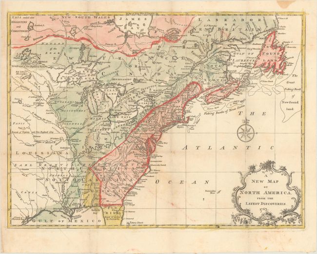
A. A New Map of North America from the Latest Discoveries, by J. Spilsbury, from London Magazine, dated 1763, hand color (14.9 x 10.9"). A fine map noting the colonial possessions in North America eastward from Texas to the Atlantic coast. It shows early settlements, forts, Indian villages and tribal territory. The colonies have boundaries extending past the map's western border. Various treaty and charter boundaries are shown. Earl Granville's Property stretches from the Atlantic west to beyond the Mississippi River. In Florida, a line from Fort St. George to St. Mark delineates the Limits Stipulated in 1738 and below, nearly to Cape Canaveral, are the Bounds of Carolina by Charter of 1665. The fishing banks off Canada are prominently outlined. The map is enhanced by a delicate title cartouche and fancy compass rose. This is the second state, published in the February 1763 edition of the London Magazine. References: Jolly (LOND) #222; McCorkle #763.7; Sellers & Van Ee #89. Condition: Issued folding on watermarked paper with some light color offsetting and an extraneous crease at bottom left.
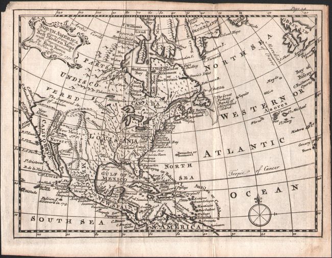
B. North America Laid Down from the Best Modern Maps with Improvements, by Emanuel Bowen, dated 1751, black & white (7.8 x 5.7"). This small map of North America extends to include all of the Caribbean Islands, Central America, and northern South America. The English colonies are confined to east of the Appalachians, with a large Louisiana extending to New Mexico. Western Canada is labeled "Parts Undiscovered" while Santa Fe and several Indian tribes are located in the Southwest. The Northwest Passage is hinted with an unclosed "Supposed Str. Of Annian." The Colorado River is named and correctly flows into the Sea of Cortez. Similar to an earlier 1747 Bowen map with notable improvements including the removal of mythical islands in Lake Superior, the designation of "New France," and Florida presented with a more accurate southern boundary. Condition: Issued folding with minor soiling.
References:
Condition: B+
See description above.