Subject: Martinique
Period: 1667 (circa)
Publication: Histoire Generale des Antilles habitées par les François ... Tome II
Color: Hand Color
Size:
11.9 x 8.5 inches
30.2 x 21.6 cm
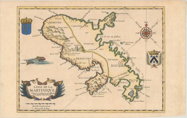
This is one of the earliest maps to focus on the island of Martinique, which was first colonized by the French in 1635. This map is a reduced sized copy of Pierre Mariette's map published circa 1660 and focuses on the division of the island between the French colonists and the "savages." On the eastern portion of the island, there are only two villages noted, both named for important caciques on the island: one near Cap Louys (Vauclin Point) where the Caribbeans meet, and one for Capitaine Pilote near Le Marin. Mount Pelee is on the western side of the island near the first French settlement of St. Pierre, where the French also built a fort. The house of "Mr. du Parquet" is also noted; Jacques Dyel du Parquet was the Governor of Martinique from 1636 until his death in 1658. The map also shows the locations of several Jesuit missions. This map includes several decorative details not found on Mariette's map, including the Royal French coat of arms, a fish, and another unidentified coat of arms. The map appeared in Jean Baptiste du Tertre's Histoire Generale des Antilles habitées par les François, published by Thomas Jolly. A scarce map.
References: Sabin #21458.
Condition: B+
A nice impression, trimmed to the neatlines and pasted onto period-correct paper.