Subject: Virginia, Civil War Reconstruction
Period: 1871 (dated)
Publication: Physical Survey of Virginia...
Color: Hand Color
Size:
34.8 x 16.3 inches
88.4 x 41.4 cm
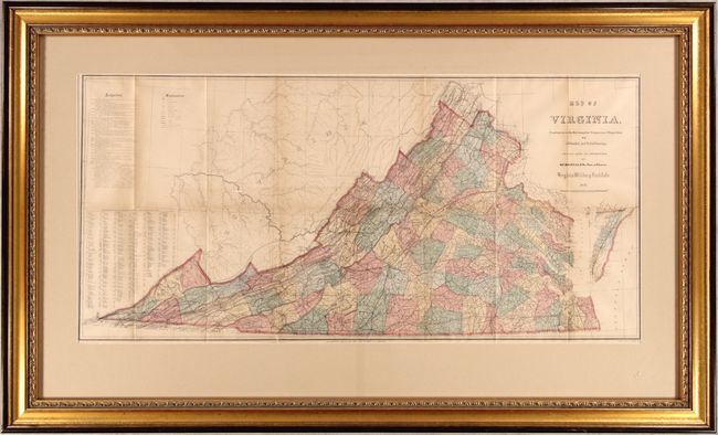
This map was issued as the frontispiece to Maury's Physical Survey of Virginia. Her Resources, Climate and Productions. Preliminary Report. No. II. While the map is dated 1871, it was published posthumously in 1878 with additions from his son, Richard Maury. The Physical Survey was intended to aid in Virginia's recovery from the Civil War with the goal of developing "the physical resources of the State, to make known its geography, and to point out the great commercial advantages which naturally arise from its situation with regard to the sea and the interior." Three editions were printed in 1868, 1869, and 1878 by the Virginia Board of Immigration.
According to Bill Wooldridge's excellent article in the Portolan (see references), the 1868 edition map was the third edition of the Bucholtz-Ludwig Map of 1858. This 1871 edition is the same width with similar presentation but has been corrected, updated, and the title credit to Ludwig has been removed. The most notable correction is the removal of the erroneous state border that locates Alleghany, Bath and Highland counties in West Virginia. Maury also states his many sources, including numerous maps and judges in the "Authorities" table at top left. Cartographically, the highly detailed map extends west through West Virginia to the Ohio River with Virginia counties highlighted in hand color. A key at identifies towns, cities, completed railroads, proposed railroads, canals, mineral springs, and more. Below the key is another additional feature showing a population table by county/township based upon 1870 census data.
Matthew Fontaine Maury (1806-73) was Superintendent of the U.S. Naval Observatory from 1842-1861. In 1855 he published his Physical Geography of the Sea, which was the first comprehensive book on oceanography. Prior to his professorship at VMI (1868-73), Maury was a Commander in the Confederate Navy.
The frame measures approximately 44 x 27".
References: Phillips (Maps) p. 991; cf. Wooldridge (Portolan - Spring 2007) pp. 26-39; cf. Stephenson & McKee, p. 268.
Condition: B+
Issued folding with some light toning. Not examined outside of frame - sold as is and not subject to return.