Catalog Archive
Auction 176, Lot 245

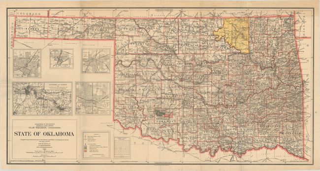
"State of Oklahoma Compiled from Official Records of the General Land Office U.S. Geological Survey and Other Sources", General Land Office

Subject: Oklahoma

Period: 1914 (dated)

Publication:

Color: Printed Color

Size:
42.7 x 21.8 inches
108.5 x 55.4 cm
Download High Resolution Image
(or just click on image to launch the Zoom viewer)

This is the scarce large-scale version of the General Land Office's map of Oklahoma. Compiled and drawn by I.P. Berthrong, the colorful map identifies counties, county seats, towns and cities. Osage is still shown as an Indian Reserve despite becoming a county in 1906. Unlike the smaller versions of the map, this large edition includes additional inset maps featuring Oklahoma City, Tulsa, Muscogee, Guthrie and McAlester. A legend at bottom further identifies National Parks, National Forests, Military Reservation, and Indian Reservations.

References:

Condition: B+

Issued folding with one small split at a fold junction. There is some minor soiling and a few repaired edge tears confined to the blank margins.

Estimate: $300 - $375

Sold for: $150

Closed on 2/12/2020

Archived