Subject: Western Nevada
Period: 1879 (dated)
Publication:
Color: Black & White
Size:
17.7 x 21.4 inches
45 x 54.4 cm
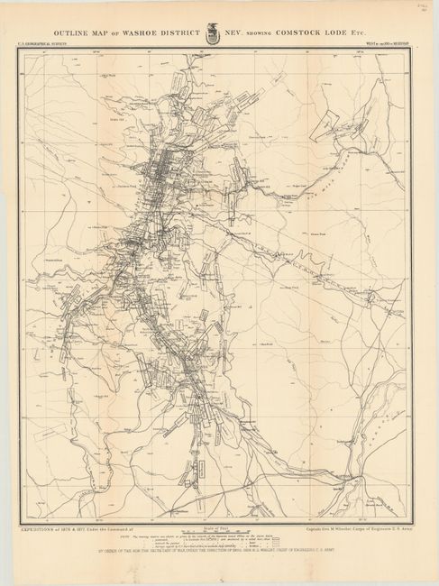
The 1870s was a period of intense effort, by such prominent people as Clarence King, Ferdinand Hayden, and John Wesley Powell, to advance the geographical knowledge of the West. These various surveys presented a threat to the Army's supremacy in the field of mapping and to the related appropriations from Congress. As a result of these pressures, the Army Corp of Engineers developed a plan to systematically survey the entire West to be called the U.S. Geographical Surveys West of the One Hundredth Meridian. The region was divided up into 95 rectangles, with atlas sheets to be prepared for each, comprising an area 2°45' of longitude and 1°40' of latitude on a scale of eight miles to the inch. Lieutenant George Wheeler was chosen to head this immense project. Surveys were conducted each summer from 1872 to 1878, after which Congress cut off appropriations for field work; thus the survey was not completed as originally envisioned. Wheeler published annual reports from 1873 to 1884, as well as the final Geographical Report published in 1889. The maps from this report are a valuable document of the record of Western exploration.
This remarkably detailed map shows the gold and silver operations in the vicinity of Virginia City. The map is a product of Capt. G.M. Wheeler's Expeditions of 1876-77 for the "Surveys West of the 100th Meridian." It is difficult to overstate the number of claims shown; perhaps as many as 100 in a patchwork mosaic cover the region so completely it is difficult to see place names. Scores of mills including Sherman, French's, Humphreys, Nevada and many more are identified. The Sutro Tunnel is detailed with the tunnel entrance located. Hundreds of settlements and villages, roads and trails, and more are presented. This area first drew the interest of gold prospectors in the 1850s. They struggled with the heavy, gooey mud that clung to picks and shovels. When assayed, this troublesome muck proved to contain silver ore worth over $2,000 a ton - in 1859 dollars - not counting the gold content! This rich lode caught the attention of President Lincoln who realized this mineral wealth could help keep the Union solvent during the Civil War. In 1864 he made Nevada a state, bypassing the sticky problem that it did not contain enough people to be constitutionally eligible for statehood. A remarkable map that attests to the manic mining activities of the day.
References:
Condition: B+
Issued folding and now flattened and backed with tissue. There is minor toning along the fold lines and a few tiny separations closed on verso with archival material.