Subject: Washington, D.C.
Period: 1926 (dated)
Publication:
Color: Printed Color
Size:
36.5 x 27.8 inches
92.7 x 70.6 cm
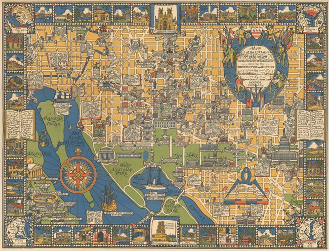
This delightful pictorial map of Washington, DC was created by Edwin B. Olsen and Blake E. Clark, and is reminiscent of the style of MacDonald Gill's 1914 map, Wonderground. Olsen and Clark developed and published three maps in this style in 1926 - Boston, Philadelphia, and Washington, DC - all supervised by Roger Scaife, a director at publishing house Houghton Mifflin. The map of Boston was published first and was highly praised, spurring the mapmakers to finalize their Philadelphia map quickly and get it to market. As a result, the Philly map was less detailed and artistic and drew criticism from the public, causing Scaife to monitor closely Olsen and Clark's work on their third map of Washington, DC, which was already in progress. With Scaife's regular feedback and Olsen and Clark's ingenuity, the District of Columbia map was published in December 1926 and received great reviews. A copy was sent to the White House, and President Calvin Coolidge noted it was "a most attractive decoration."
The map is centered on the White House with the boundaries extending purposefully to include important landmarks: Sheridan Circle in the north, Library of Congress in the east, the War College and US Navy Yard in the south, and Arlington Cemetery and Georgetown College in the west. With Olsen and Clark's background in architecture, much of the focus of the map is in the numerous important buildings throughout DC. To ensure that these buildings were properly represented, the mapmakers decided to depict them two-dimensionally and also always from the front facade. In addition, they developed a "scale of interest" that gave them the artistic freedom to illustrate the size of each building based on its importance, rather than its true size relative to other buildings. Open books are scattered throughout the design with historical facts about the nation's capital, and the map border is filled with vignettes of additional important buildings and historical sites both in and around DC. The corners of the map feature insets with John Smith's 1606 map, maps of Washington from 1792 and 1800, and a map of the cities surrounding Washington. An impressive, colorful map filled with historical facts and geographical details. Published by Houghton Mifflin Company.
References: Hornsby (Picturing America) pp. 20-21 & plate 48; Rumsey #8923.
Condition: A
Issued folding and professionally backed in thin, archival tissue to provide support and repair a few tiny holes at fold intersections.