Subject: Arizona
Period: 1876-1902 (dated)
Publication:
Color:
Three maps showing the evolution of the Territory of Arizona including:
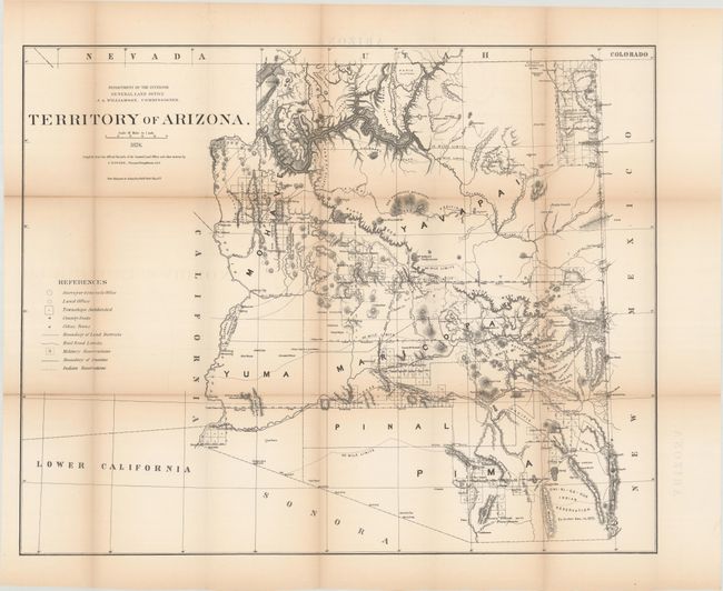
A. Territory of Arizona, dated 1876, black & white (28.9 x 23.1"). A large and uncommon map of the territory that shows Tucson as the capitol and depicts a very early naming of Phoenix, having recently been shown as Maricopa Villages. Only six counties are named: Yavapai, Mohave, Yuma, Maricopa, Pinal and Pima. The sheet locates towns, county seats, Indian and Military reservations, military forts and camps, topography through hachure, and watershed. This map was produced by the GLO as part of a series of maps of the states and territories to celebrate the Centennial. At the time they were recognized as the most accurate and detailed maps to date and were widely used by commercial mapmakers. Condition: Light toning with several fold separations that have been closed on verso with archival tape. (B)
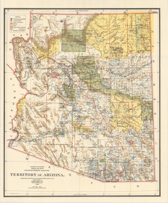
B. Territory of Arizona, dated 1899, printed color (16.9 x 20.1"). A colorful map with great detail of railroads, cities, roads, extent of surveying, etc., thirteen years before statehood. A legend at upper left provides a key to color coding for topography, Indian Reservations, Military Reservations, and Forest Reserves. Several private land claims, confirmed and unconfirmed, are also shown through color coding. Much of the territory remains to be surveyed and townships subdivided. Locates the Hualpai Indian Reservation, and the Hopi Reservation is still labeled the Moqui Indian Reservation. The Grand Canyon Reserve is shown. The brown hachured mountain areas and the blue waterways combine to provide great visual impact. Information includes watershed, mountains, railroads, wagon roads, private claims, unsurveyed townships, etc. Condition: Fine (A+)
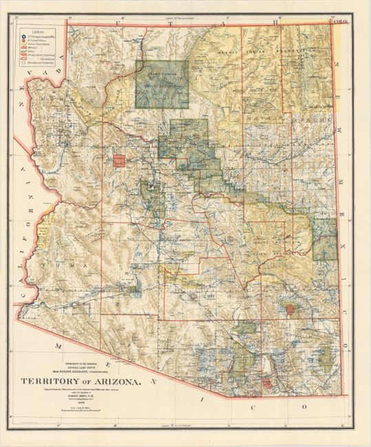
C. Territory of Arizona, dated 1902, printed color (16.9 x 20.2"). An updated map from the "B" map above, ten years before statehood. The extent of nine Indian reservations, four Military reservations, including Fort Apache, and numerous Forest Reservations are clearly shown in different colors. Private claims, confirmed and unconfirmed, are outlined in red, and the Grand Canyon Forest Preserve is noted. The 1902 edition is less common than most other issues. Condition: Fine (A+)
References:
Condition:
Issued folding. See description above for additional details.