Subject: Southwestern United States
Period: 1881 (dated)
Publication: Second Annual Report of the U.S. Geological Survey
Color: Printed Color
Size:
17.9 x 28.9 inches
45.5 x 73.4 cm
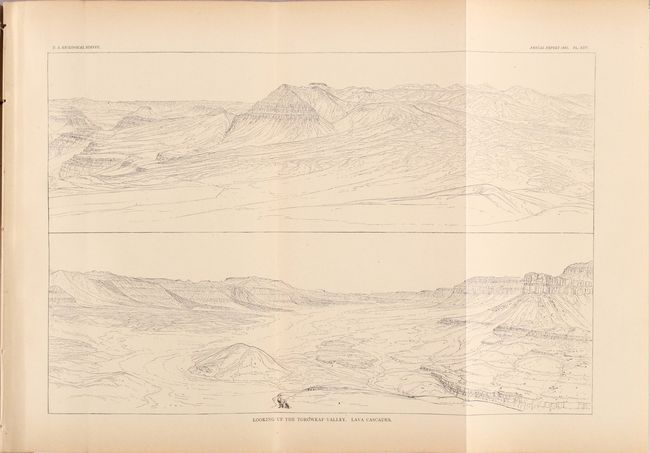
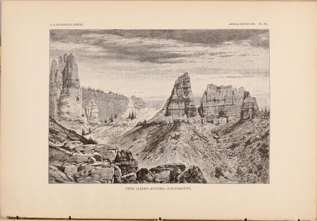
This disbound volume contains Dutton's famous report on the Grand Canyon, which was issued in the 2nd Annual Report of the U.S. Geological Survey. This classic piece of western Americana describes the rock strata and physical features of the Grand Canyon of the Colorado River. The engraved plates, many of which are folding, show panoramic landscape views of the canyon, rather than illustrating aspects of the rock strata. As such, this work is as much a scenic guidebook as it is a scientific reference. Ten of the engravings are by Thomas Moran, the noted western landscape artist, and bear his distinctive signature marks. Other splendid views are by H.H. Nichols and W.H. Holmes. A few of the titles of the folding plates include: "Plateau Scenery - the Mesa Verde"; "Looking up the Toroweap Valley. Lava Cascades"; "The Panorama from Point Sublime - Looking East (also south and west)"; the "Vermillion Cliffs at Kanab"; and "Kanab Canon."
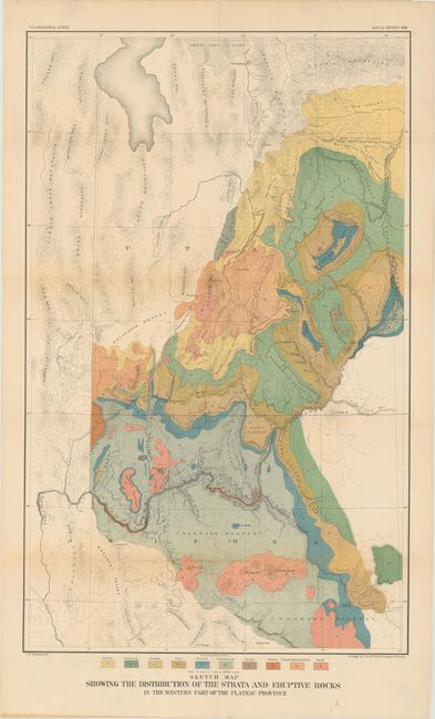
Included in the rear pocket of the report is the very detailed and strongly colored geological map from the U.S. Geological Survey (18 x 29"). It details the region from Prescott (Ft. Whipple) and Camp Verde north through the Grand Canyon and Marble Canyon, today's Canyonlands National Park, Moab, and the southern portion of the Great Salt Lake. The map locates the Wasatch and Uintah Mountains, the Bad Land Cliffs (Book Cliffs), the San Juan River, etc. and has remarkable detail of the watershed and topography. This thematic map identifies ten geological types through color including: Tertiary, Cretaceous, Jurassic, Trias, Permian, Carboniferous, Silurian, Archaean, Trachyte, Rhyolite & Andesite, and Basalt. Engraved by J.H. Renshawe. A very colorful and handsome map.
Quarto, 120 pages with 27 plates, 15 wood engravings, and the folding map. Disbound.
References:
Condition: B+
Condition code is for the map, which is very good with a few small splits at the fold junctions and a 3" separation along the lower horizontal fold that has been closed on verso with archival tape. Disbound text with the first half of the signatures separated from the text block. Text and plates are very clean with just a hint of toning and edge tears to the first two pages of text.