Subject: Colonial Upper Midwestern United States, River Longue
Period: 1703 (published)
Publication: New Voyages to North America
Color: Black & White
Size:
13.3 x 8.4 inches
33.8 x 21.3 cm
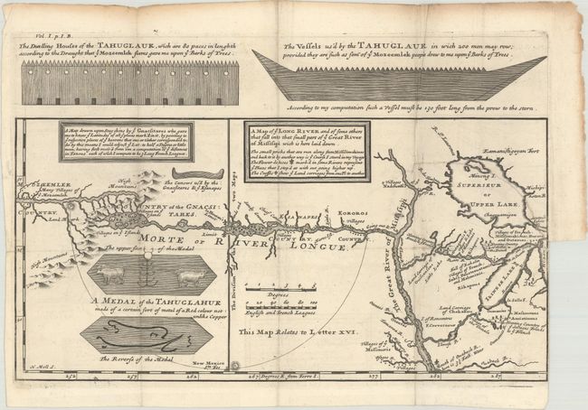
One of the most influential, and fanciful, maps in American cartographic history. It purports to show the mythical River Longue flowing from the mountains in the west (Rocky Mountains), home to the Gnacsitares Indians, and connecting to the Mississippi River. A number of relatively short portages across the High Mountains to what must be the River of the West are depicted. On the western side of the mountains is another river, presumably flowing into the Pacific. Lahontan's concept was copied by virtually all contemporary cartographers including Senex, Popple, and De l' Isle, thus perpetuating the myth through the 18th century. The map also includes balloon-shaped Lakes Superior and Michigan. This is the scarce first English edition, engraved by Herman Moll, with numerous interesting English text notations.
Louis Armand, Baron de Lahontan served ten years in the French military in Canada, was involved in the Indian Wars, and commanded several posts in the west. He traveled extensively in the Wisconsin and Minnesota region and the upper Mississippi Valley. Upon his return to Europe he wrote his enormously popular travelogue, Nouveaux Voyages de M. le Baron de Lahontan dans l'Amerique Septentrionale. In it he embellished his knowledge of the geography of the Great Lakes region, invented Indian tribes, and created several fictions, particularly the River Longue, which he claimed extended from the Mississippi River to the Rocky Mountains. Over twenty editions of his book were published between 1703 and 1741, including editions in French, English, Dutch and German. The immense popularity of the book resulted in his distorted cartography being accepted by several eminent cartographers who incorporated the "Lahontan" concepts into most 18th century maps.
References: Kershaw #306; Schwartz & Ehrenberg #81, p. 142.
Condition: B+
Fine impression on thick paper with large unicorn watermark, folding as issued with a few short fold separations that have been archivally repaired and soiling along the edges of the sheet. There is a binding trim at right with an associated 3" binding tear into map, closed on verso with archival tape.