Subject: Colonial Louisiana, Mississippi River
Period: 1720 (circa)
Publication: Het Groote Tafereel der Dwaasheid …
Color: Hand Color
Size:
6 x 7.1 inches
15.2 x 18 cm
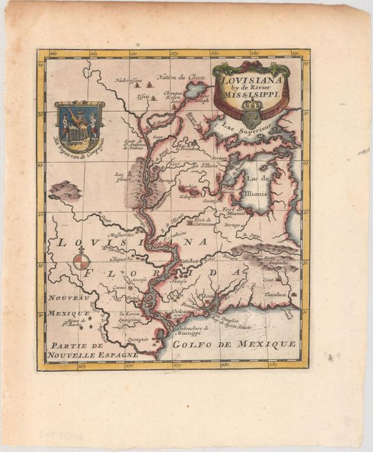
This scarce little map depicts the French possessions in the Mississippi River valley. The map is largely based on Hennepin with enlarged Great Lakes and the Mississippi located too far to the west of its true course. Numerous forts, proposed colonial settlements, and Indian villages are located as well as Mines de St. Barbe. The map is decorated with a title cartouche incorporating the arms of John Law and a crest showing two Native Americans holding a large golden horn of plenty from which the Mississippi flows.
This map was most likely engraved by Leonard Schenk. It accompanied a satirical account of the collapse of the French Compagnie de la Louisiane d'Occident, known as the Mississippi Bubble incident, and one of the most infamous financial meltdowns in history. John Law, a Scottish financier, established the company in 1717 and was granted control of Louisiana. Law developed an elaborate plan to exploit the fabulous resources of the region, which quickly gained popularity and people rushed to invest. Share prices opened at 500 livres and rapidly rose to 18,000 livres. At this point the bubble burst; speculators cashed in, caused a run on the shares, and the company went bankrupt. As a consequence of the failure, confidence in other similar companies failed, and thousands of individual investors across Europe were ruined.
References:
Condition: A
A crisp impression with light toning and foxing confined to the left and top blank margins.