Subject: Mexico
Period: 1930 (circa)
Publication:
Color: Printed Color
Size:
40 x 25.1 inches
101.6 x 63.8 cm
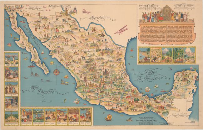
This delightful pictorial map of Mexico was designed to encourage tourists to visit the numerous historic and cultural sites throughout the country. Imagery of these sites, along with local customs, activities, flora and fauna fill the map. A large inset fills the Gulf of Mexico and features the chorus of the national anthem of Mexico, numerous figures in indigenous costumes, and a quote from the beginning of the volume on Mexico from William H. Prescott's historical series The Nations of the World. Smaller insets in the Pacific Ocean depict important dates and periods in the history of Mexico and traditional Mexican customs, such as the national dance, a bull fight, and a cock fight. The map was created by Miguel Gomez Medina and was given to tourists at various hotels and restaurants in Mexico City. Several versions of this map were published: larger versions in both English and Spanish and a smaller version that appeared several years later. This is the large Spanish version, with the addition of 6 planes added just across the border in the United States. Printed by La Ensenanza Objetiva, and published by Margaret M. Crane & Eugenio Fischgrund.
References:
Condition: A
A superb bright example, backed in archival tissue to provide support and repair some tiny tears and chips along the edges of the sheet.