Subject: Cartographic Miscellany, World War II, Germany
Period: 1944 (dated)
Publication:
Color: Printed Color
Size:
41.8 x 13.8 inches
106.2 x 35.1 cm
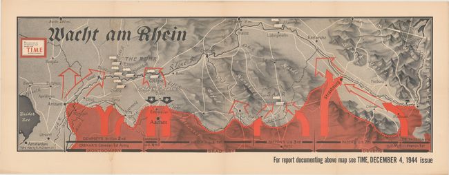
This fascinating map is an enlarged version of one by Robert Chapin that was included in the December 4, 1944 issue of Time Magazine. It depicts the region along the Rhine River from Basel, Switzerland to Amsterdam with north oriented at top left. Allied forces are prominently depicted in red overprinting at bottom with bold arrows showing their planned advances. Various military divisions are noted as well including forces from Britain, Canada, United States, and France. Two opposing black arrows with swastikas are shown meeting the Allied forces near Eschweiler, a town that experienced heavy damage during this stage of the war.
Robert M. Chapin began working for Time magazine in 1937 after a short stint as a photo retoucher at Newsweek. During World War II, his prolific team produced about a map every day to keep up with the breaking war news. Chapin would spend a total of 33 years with the company and retired as the cartography head of the magazine.
References:
Condition: A
Issued folding with a few faint dampstains.