Subject: Chicago, Illinois
Period: 1839 (published)
Publication: Sen. Doc. 140., 26th Congress, 1st Session
Color: Black & White
Size:
11.8 x 9.6 inches
30 x 24.4 cm
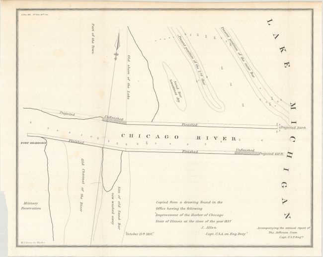
This very early, untitled map of Chicago depicts the area where the Chicago River meets Lake Michigan. It was apparently copied from "a drawing found in the Office" made by Captain J. Allen in 1837. In a spare style it shows the old shore of the lake, an old channel of the river, sand bars, a military reservation, Fort Dearborn, and finished, unfinished, and proposed sections of the harbor.
The map was originally issued in the 26-page Report from the Secretary of War, Transmitting Copies of Reports of the Topographical Bureau in Relation to Internal Improvements in the Territory of Wisconsin..., the report of Captain Thomas Jefferson Cram of the Topographical Engineers. Cram (1804-1883) was born in New Hampshire and graduated fourth in his class from the United States Military Academy in West Point, New York. In 1838, he joined the U. S. (Army) Topographical Engineers, where he received a captain's commission and was assigned to the Great Lakes harbor surveys. In the 1840s he surveyed the Michigan and Wisconsin boundary, and in 1855 he became Chief of the Topographical Engineers, Western Division. He was promoted to Lt. Colonel in 1861, served with distinction in the Civil War and was rewarded with the title of Brevet General in 1866. He retired in 1869.
References: Claussen & Friis #333.
Condition: A
Issued folding on a bright sheet with a few faint spots of foxing.