Subject: North Atlantic
Period: 1818 (published)
Publication: Sulle Antiche Mappe Idro-Geografiche Lavorate in Venezia
Color: Black & White
Size:
14.3 x 10.6 inches
36.3 x 26.9 cm
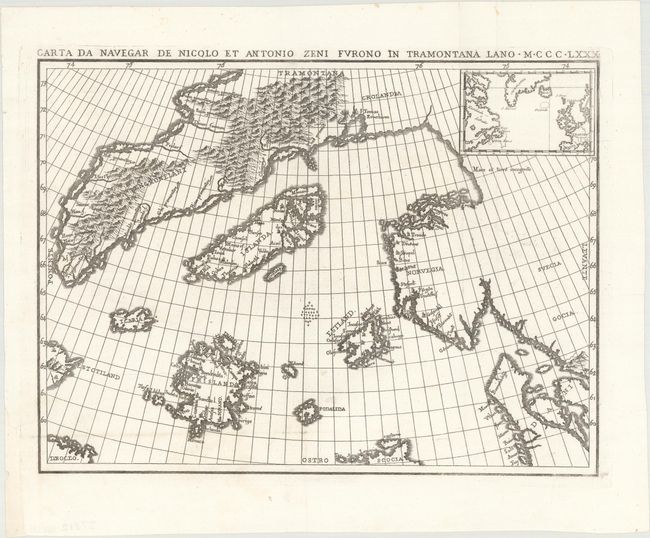
This interesting map of the North Atlantic is one of the most enduring cartographic mysteries. Known as the Zeno map, it first appeared in Venice in the year 1558 with an account of the exploits of Nicolo and Antonio Zeno into the region in 1380. The brothers allegedly traveled to Frisland (a fictitious island south of Iceland, perhaps the Faroe Islands) and the east coast of Greenland where they heard from the natives of the lands to the west called Estotiland (Labrador) and Drogia (Newfoundland). The account was published by a Zeno ancestor purportedly from a surviving journal and manuscript map. It was probably created to give Venice, the author's native city, the credit for discovering America more than a century ahead of Columbus.
The narrative of the Zeno’s adventures was disputed at the time of publication and remained a source of controversy even into the 20th century. Even so, it was still taken seriously by many scholars and cartographers because it delineated certain features of the northern Atlantic regions that cannot be traced on earlier charts that have survived. The map was reproduced for Ruscelli's edition of Ptolemy, used as a source for Mercator's important world map of 1569, incorporated into Ortelius's 1570 map of the Arctic regions. It was used by early English explorers in search of the Northwest Passage, and its errors in latitude are known to have deceived Frobisher. Thereafter story remained dormant for about a hundred years until it was revived by Forster and Buache in the late 18th century. The Hakluyt Society published an English translation in 1873 and in 1883 Baron Nordenskiöld argued in favor of the validity of the narrative. Finally in 1898, Frederick Lucas concluded that it was a hoax after an extensive study in which he identified its main source to be Olaus Magnus' Carta Marina, along with other 15th and 16th century maps.
The map offered here is from an Italian publication by Placido Zurla. It faithfully reproduces the original map and includes a small inset showing a modern map of the region for comparison.
References: cf. Burden #26.
Condition: A
A dark impression on a bright sheet, issued folding.