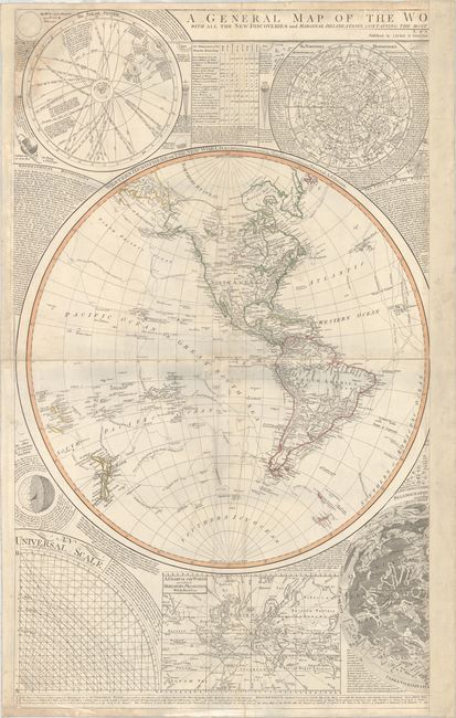
Subject: Western Hemisphere - America
Period: 1794 (circa)
Publication:
Color: Hand Color
Size:
24.3 x 40.8 inches
61.7 x 103.6 cm
This is the Western Hemisphere half of Dunn's fabulous large-format world map, one of the most attractive wall maps from the end of the 18th century. It is surrounded by a chart of the solar system, the northern celestial hemisphere, a universal scale, an inset world map on Mercator's projection, and the western half of a map of the moon's surface after Father Riccioli. The large Western Hemisphere map is titled Western Hemisphere or the New World by Mr. d'Anville. With the New Discoveries and Several Additions. It shows the tracks and discoveries of major voyages, including those of Captains George Anson, Louis Antoine de Bougainville, Lazier Bouvet, and James Cook. The map was first issued in 1772 by Robert Sayer with the title Scientia Terrarum et Coelorum: or, the Heavens and Earth Astronomically and Geographically Delineated and Display'd... and was updated and reissued several times over a 30-year period. There were further issues by Sayer with the same title in 1781 and 1784, and the title was then updated to A General Map of the World, or Terraqueous Globe for the 1787 issue.
This example, issued by Laurie & Whittle, shows great improvements to the cartography primarily due to Cook's second and third voyages. Alaska and the Pacific Northwest have now begun to take shape with numerous new place names along the coast. The previously noted entrances of Admiral Fonte, Juan de Fuca, and Martin d'Aguilar in the Pacific Northwest are now gone; however, this edition includes not just one but two proposed locations for the River of the West. The northern location connects to R. St. Charles and Lake Winnipeg, while the southern location connects to Pikes Lake and Mantons River. There are also updates to the cartography in Canada and the Arctic based on Hearne's explorations in the region. A number of new islands appear in the Pacific, such as Hawaii and New Caledonia. In South America, a small remnant of the mythical L. Parima still appears in Guiana.
Printed on two sheets, joined.
References:
Condition: B+
There is light soiling and light damp stains in the top left corner. Backed in linen to repair some short edge tears and a small hole in an unengraved area near the center of the map.