Subject: Oklahoma
Period: 1904-26 (dated)
Publication:
Color: Printed Color
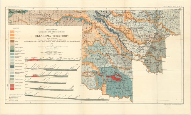
A. Preliminary Geologic Map and Sections of Oklahoma Territory, by C.N. Gould, dated 1904 (20.1 x 11.0"). A colorful map of present-day western Oklahoma that is the first geological map of the state (then territory). Layered on top of the base U.S.G.S. map are 19 different geologic types identified by both color and texture including sand, sandstone, and igneous rocks. The legend further identifies five different spring types, and six cross-sections augment the map. Issued in the U.S.G.S. Water Supply Paper No. 148. For an interesting history of this map, click a href="http://ogs.ou.edu/docs/geologynotes/GN-V76N2.pdf">here (page 4). Condition: Issued folding on a bright sheet. (A+)
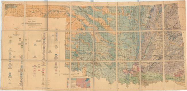
B. Geologic Map of Oklahoma, by Hugh D. Miser, dated 1926 (65.6 x 31.3"). This mammoth map is drawn on a scale of approximately 7 miles per inch and was a result of a collaboration between the U.S.G.S., the Oklahoma Geological Survey, and oil companies in the state. It shows a complete view of the geology with numerous geological types identified through both color and texture along with an inset map showing the sources from which the map was compiled. This example was previously owned by Norval Ballard, a geologist who worked for Phillips Petroleum and Kerr McGee (his name and stamp is on verso). Dissected and backed with linen. Condition: Light toning, scattered foxing, and minor soiling. There are pinholes in the far corners of the sheet and a tiny chip in the top left corner of the sheet. The linen is also fraying a bit along the sheet edges. (B)
References:
Condition:
See description above.