Subject: Arizona
Period: 1899-1906 (dated)
Publication:
Color: Printed Color
Size:
16.9 x 20.2 inches
42.9 x 51.3 cm
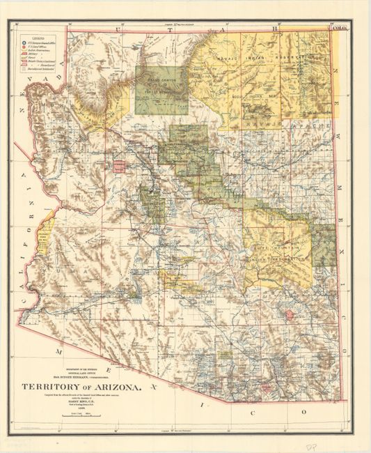
A. Territory of Arizona, dated 1899. A colorful map with great detail of railroads, cities, roads, extent of surveying, etc., thirteen years before statehood. A legend at upper left provides a key to color coding for topography, Indian Reservations, Military Reservations, and Forest Reserves. Several private land claims, confirmed and unconfirmed, are also shown through color coding. Much of the territory remains to be surveyed and townships subdivided. Locates the Hualpai Indian Reservation, and the Hopi Reservation is still labeled the Moqui Indian Reservation. The Grand Canyon Reserve is shown. The brown hachured mountain areas and the blue waterways combine to provide great visual impact. Information includes watershed, mountains, railroads, wagon roads, private claims, unsurveyed townships, etc.
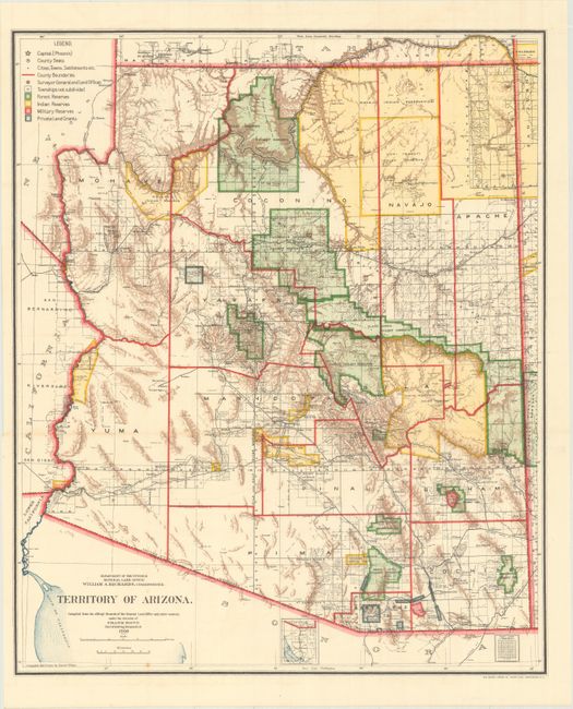
B. Territory of Arizona, dated 1906. An updated map from above, six years before statehood. The extent of nine Indian reservations, four military reservations (Fort Apache, Fort Grant, Fort Huachuca, and Fort Whipple), and numerous National Forest Reserves are clearly shown in different colors. Private land grants are outlined in gray. Drawn by Daniel O'Hare, and lithographed by the Norris Peters Co., Photo-Litho.
References:
Condition: A
Both examples issued folding and near fine but for a couple of negligible spots at bottom.