Subject: China, Korea & Japan
Period: 1655 (circa)
Publication:
Color: Hand Color
Size:
23.3 x 17.8 inches
59.2 x 45.2 cm
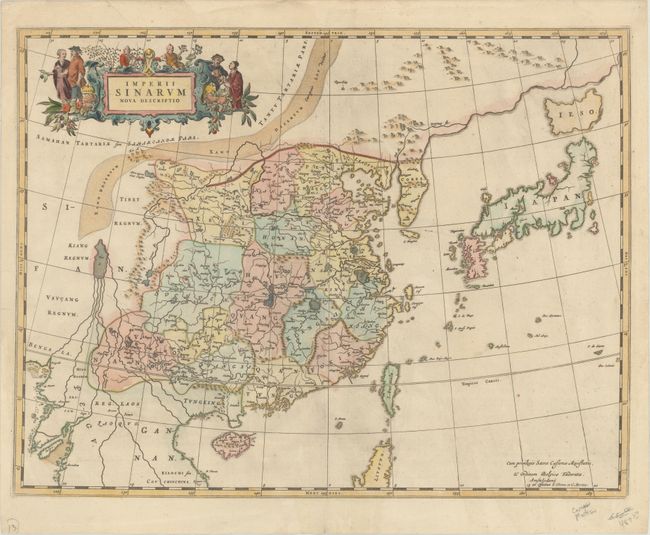
Superb map of the Chinese Empire based on the compilation of the Jesuit Father Martino Martini who traveled through the region between 1643 and 1650. This was a period of great internal unrest and his was a perilous journey. He was able to travel inland to the Great Wall and for the first time determined with any scientific accuracy the astronomical position of many cities and topographical features. After establishing a mission in Zhejiang province he returned to Rome via Amsterdam, where he met Joan Blaeu. Blaeu then prepared a group of eight maps covering China in great detail. This map presents Korea as a peninsula for the first time on a European map. The depiction of Japan follows the Blancus/Moreira type, but with Ezo as a separate island. At top is an ornamental title cartouche surrounded by Chinese peasants. It was originally published in Novus Atlas Sinensis, the first European atlas based on Chinese geographical sources. This is the fourth state, with the imprint of Covens & Mortier, published in various composite atlases. Blank verso.
References: Caboara #43.4; Goss (Blaeu) pp. 210-11; Van der Krogt (Vol. I) #8410:2B; Walter #36.
Condition: A
A nice impression with minor cockling of the paper and a tear at top left that just enters the map border and has been closed on verso with archival tape. The left blank margin has been reinforced with old paper on verso, repairing a couple of short tears. There are remnants of paper tape along the edges of the sheet on verso.