Subject: World
Period: 1551 (circa)
Publication: Cosmographia...
Color: Black & White
Size:
10.8 x 7.4 inches
27.4 x 18.8 cm
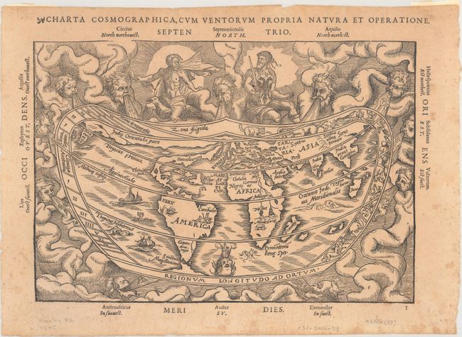
This early map is based on the now lost world map of Gemma Frisius [1540], which is significant in the history of the mapping of America. The continents are broadly based on Mercator's globe gores of 1541, but North America is shown as a long slender landmass labeled Baccalearium in reference to the cod fishing region off the coasts of New England and Canada. It employs a cordiform projection and depicts a distinct northern passage to Asia over the top of North America. There are few geographical features other than the prominent twin lake sources of the Nile in Africa. The heart-shaped border of the map contains signs of the zodiac within a cloud background filled with mythical figures and wind heads. One of the deities at top sports the design of the Holy Roman Emperor's double eagle on his breastplate and the three cadaverous wind heads at bottom represent plague-carrying winds of the south. This is an example from the first of three woodblocks, issued with both Latin and French text. This woodblock is distinguishable by the appearance of "Europa" at an angle but lacking the names Anglia and Scotia.
References: Shirley #82.
Condition: B+
Issued folding with light toning and scattered foxing. A tiny fold separation along the top sheet edge at right has been closed on verso with archival tape. There are remnants of hinge tape on verso.