Subject: United States
Period: 1860 (dated)
Publication: New General Atlas
Color: Hand Color
Size:
21.4 x 13.2 inches
54.4 x 33.5 cm
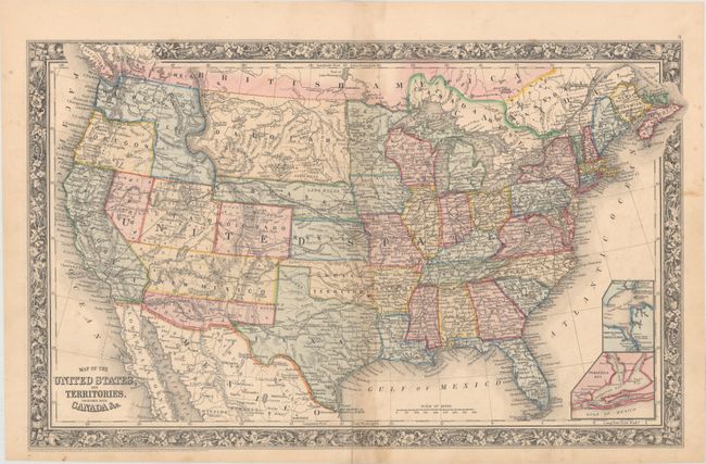
A terrific map published at a time when many territorial borders were rapidly changing, giving this map some of the most unique border configurations available. Utah is still oversized as the newly formed Nevada has its border at the 116° longitude, two full degrees from its present location. Colorado has just been formed and the map locates Denver City, Ft. St. Vrains and little else. New Mexico extends between Texas and California, but Arizona Territory occupies its southern half. This is the rare Confederate Territory of Arizona as established by the Confederate General Baylor. Oregon state has just been formed, leaving its eastern half to Washington Territory, which is now shaped as an upside down "L" and bordering with Utah in the south. Nebraska has a long panhandle that extends west to the border with Washington and Utah. The huge Dacotah Territory extends between the Continental Divide to the Red River at Minnesota, and is bounded at top and bottom by Canada and Nebraska Territory. Oklahoma is Indian Territory. An extensive railroad network runs throughout the East, with proposed railroads, wagon roads and emigrant routes shown in the western territories. Insets of Hampton Roads and Norfolk Harbor, and Pensacola Bay are shown in the Atlantic. The map has the first edition floral borders.
References:
Condition: B+
Original color with light toning along the centerfold, a 1.75" centerfold separation at bottom, and a few minor stains.