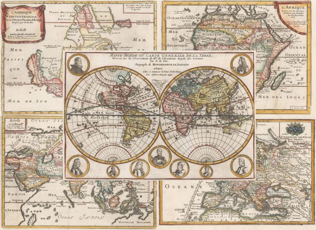
Subject: World & Continents
Period: 1705-40 (circa)
Publication: L'Atlas Curieux
Color: Hand Color
This appealing matched set of maps reflects several geographical myths that were prevalent at the beginning of the eighteenth century.
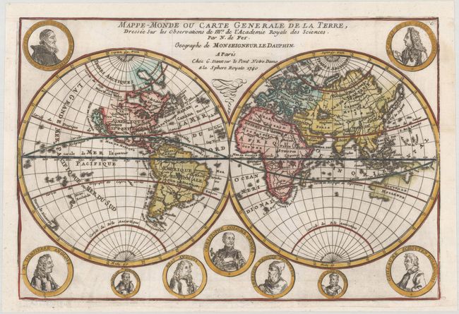
A. Mappe-Monde ou Carte Generale de la Terre, Dressee sur les Observations de Mrs. de l'Academie Royale des Sciences, dated 1740 (13.5 x 9.0"). Fine double hemispheric map that features California as an island. Surrounding the hemispheres are nine medallion portraits of explorers, including La Salle, Tachard, Dampier, Magellan, Drake, Columbus, Vespucci, Marco Polo, and Schouten. The map shows early mapping of North America with the Great Lakes not completely formed. The northeast coast of Asia includes a coastline labeled Roye. de Coree stretching off the map in the direction of North America. Australia and New Zealand are tentatively drawn and named Nouvelle Hollande and Nouv. Zeeland. According to Shirley, this map may have been copied directly from the similar map by Mortier (see Shirley #572); however, since the dating on the Mortier map is uncertain, it is possible that Mortier copied de Fer. This is a later edition by De Fer's son-in-law Guillaume Danet that is not noted in Shirley.
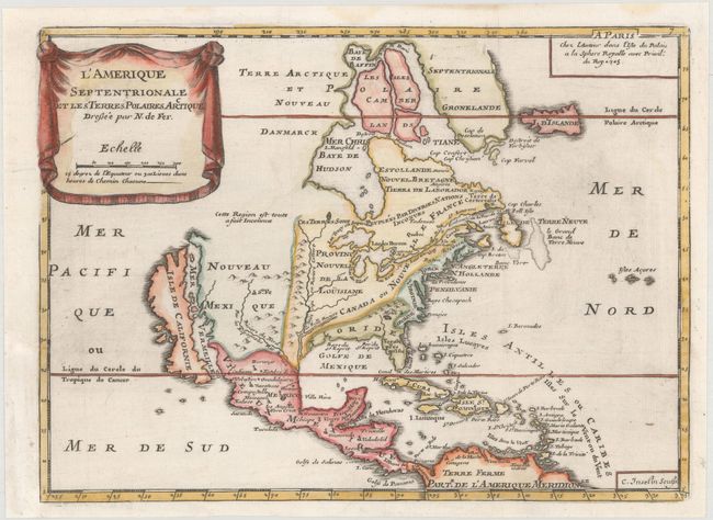
B. L'Amerique Septentrionale et les Terres Polaires Arctique, dated 1705 (11.1 x 8.0"). This uncommon map is based on Coronelli's large, two-sheet depiction of the continent from 1692. California is depicted as an island on the second Sanson model with two indented bays in the northern coast. De Fer's map deviates from Coronelli's cartography in a couple of regions; Lake Ontario forms the headwaters of the St. Lawrence River leaving the other Great Lakes landlocked, and Baffin island is shown. The map is small, and thus not heavily detailed, but the eastern coast includes the names of Boston, New York, Providence, Chesapeake Bay, Virginia, Carolina and Florida. The title is displayed on a drape-style cartouche. This is the third state of the map, engraved by C. Inseln.
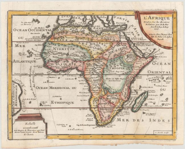
C. L'Afrique Dressez sur les Dernieres Relations, dated 1705 (10.8 x 8.3"). This is an updated edition of De Fer's map of Africa with several geographic errors corrected. The source of the Nile River is now shown correctly in Abyssinia, and the two sub-equatorial Ptolemaic lakes have been removed and replaced with a notation that the vast region in Ethiopia is unknown. The mythical second island of St. Helena, which appears on many maps of this time period, has also been eliminated. The map is adorned with two decorative cartouches. Engraved by C. Inselin.
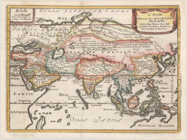
D. L'Asie Dressee sur Divers Relations, dated 1705 (10.9 x 8.0"). This is an interesting and very unusual map of the Asian continent. La Grande Tartarie is divided horizontally, with the upper portion noted as "dominated by the Moscovites" and the southern portion described as dominated by various Kings and Princes and extending between the Caspian Sea and China. The interior is filled with details, including an unnamed Lake Chiamay with four rivers flowing south and the Great Wall of China. The Caspian Sea is presented in an unusual shape. The coastline of a portion of Nouvelle Hollande appears at bottom right. Adorned with two drape-style cartouches.
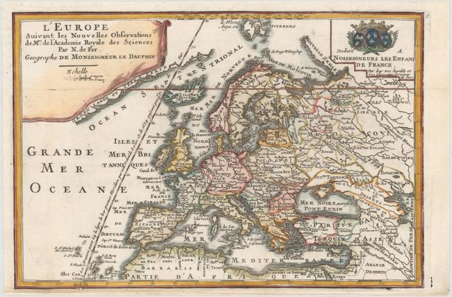
E. L'Europe Suivant les Nouvelles Observations de Mrs. de l'Academie Royale des Sciences, circa 1717 (13.1 x 8.9"). This small map of Europe extends east to the Caspian Sea and south to North Africa. A partial coastline of Greenland appears adjacent to the title cartouche. One line of longitude is shown running through Isle de Fer with a notation that it serves as the prime meridian based on a decree by Louis XIII in 1634. Adorned with a drape-style cartouche and a coat of arms with a dedication to the Children of France.
References: Burden #696; McLaughlin #111; cf. Shirley #601.
Condition: A
Excellent impressions on clean, bright sheets, issued folding with binding trims professionally replaced. The world map has professional repairs to a 2" binding tear at left and a fold separation at top right, and has been remargined at top with a small portion of the neatline replaced in facsimile. The map of Europe has a professionally repaired hole in an unengraved area of the map at bottom left.