Subject: Atlantic Ocean, Indian Ocean
Period: 1703 (published)
Publication: A New Voyage Round the World...
Color: Hand Color
Size:
11.7 x 5.8 inches
29.7 x 14.7 cm
William Dampier (baptized 1651-1715) was a buccaneer (pirate) and sea captain. He was the first Englishman to explore parts of New Holland and New Guinea, and was the first man to circumnavigate the world three times.
In the 1670s he crewed with buccaneers on the Spanish Main of Central America, which eventually led to his first circumnavigation. On the ship Cygnet, following Pacific-spanning raids that included the East Indies, Manila, and the Spice Islands, Dampier's ship was beached on the northwest coast of Australia in 1688. Waiting for repairs, his scientific interest surfaced as he made notes and drawings on the local fauna and flora. Following three years of further adventures he returned to England. In 1697 he published his experiences in A New Voyage. Described as one of the greatest tales of adventure and exploration ever written, the book was published in several languages. It is reported that Captain Cook used Dampier's nautical observations on his voyages, and Charles Darwin found his books so useful that he took them aboard the Beagle.
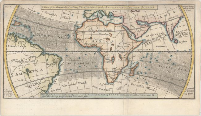
Although his name does not appear on the map, it was engraved by Herman Moll. It is identical in style and size to the map of the winds in the South Ocean that does bear Moll's name. The map depicts the winds from 30 degrees north latitude to 30 degrees south latitude in the North Sea, The Ethiopian Sea and Indian Ocean. At the right are portions of Asia; in the center is Africa; and on the left is the east part of South America. A note at the bottom states, "Note, that the Arrows in the void Spaces shew the Course of the Shifting Trade-Winds, and the Abbreviations, Sept &c. Shew the Times of the year when such Winds blow".
The map appeared in William Dampier's description of his first circumnavigation between 1679 and 1691, during which he was among the first group of Englishmen to land in New Holland (Australia). His memoir, A Voyage Round the World, was first published in 1697, and went through four more editions in the next six years.
References: Shirley (BL Atlases) G.DAM-1a #8.
Condition: B+
Issued folding and now flattened with a small hole along the top left border that has been archivally infilled on verso. The folds have been archivally reinforced on verso.