Subject: World
Period: 1788 (circa)
Publication: Atlas Encyclopedique
Color: Hand Color
Size:
13.6 x 9.3 inches
34.5 x 23.6 cm
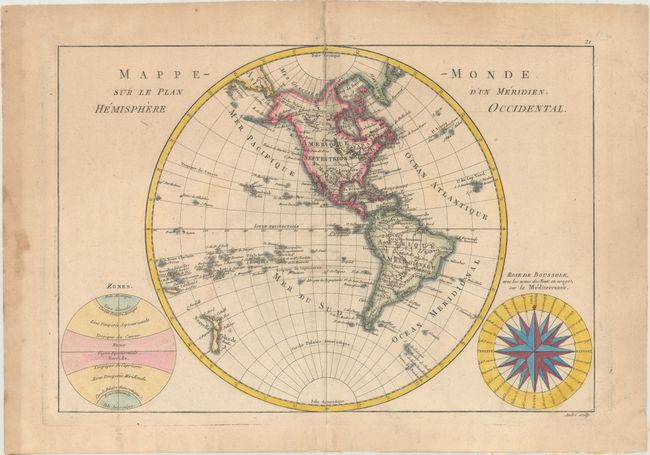
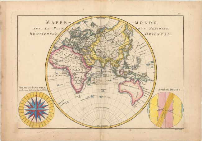
This terrific pair of copper engravings shows the Western and Eastern hemispheres in fine detail. They were engraved by Andre under the direction of Rigobert Bonne (1727-1795), the Director of the Depot de la Marine and Royal Hydrographer to the King, and published by Nicolas Demarest in his Atlas Encyclopedique. Both maps feature a large wind rose called "Rose de Boussole," showing wind directions taken from charts in use in the Mediterranean Sea (on the Western Hemisphere map) and the ocean (on the Eastern Hemisphere map). The Western Hemisphere map depicts North and South America with the Atlantic and Pacific islands and New Zealand. Alaska is approximately the correct shape reflecting Cook's discoveries. Opposite the "Rose de Boussole" is a second diagram with information on the poles and the circles of the earth. The Eastern Hemisphere map covers the countries of the world from Europe to Africa and Asia to Australia. Tasmania is attached to the Australian mainland. In the bottom right corner, there is a sphere showing the equator, tropics, ecliptic, and the Arctic and Antarctic circles.
References:
Condition: B
Nice impressions with light offsetting, minor soiling, and several archivally repaired centerfold separations. There is hinge tape on the versos and show-through of non-archival tape residue along the left sheet edges, well away from map image.