Subject: Boston, Massachusetts
Period: 1926 (dated)
Publication:
Color: Printed Color
Size:
37.2 x 28.3 inches
94.5 x 71.9 cm
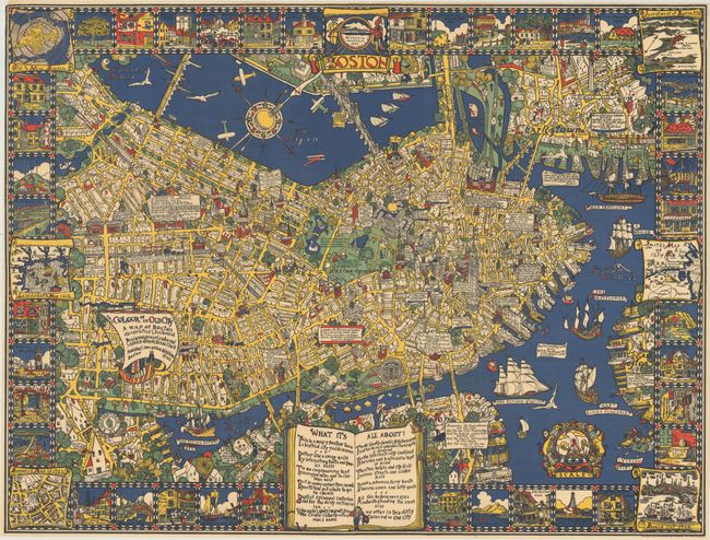
This delightful pictorial map of Boston was created by Edwin B. Olsen and Blake E. Clark, and is reminiscent of the style of MacDonald Gill's 1914 map, Wonderground. When published in 1926, this map of Boston was one of the "first stand-alone, full-color pictorial maps produced in the United States" (Hornsby, p. 18). Creating the map took Olsen and Clark six months of exhaustive research of maps, history books, diaries, and old documents, which they conducted primarily at the Boston Athenaeum and the Boston Public Library. Olsen's goal for the map was to create something "picturesque and yet informative, could avoid the stereotyped network of dull, straight lines, and still keep the city within bounds." The end result was impressive, with colorful imagery, historical facts, and geographical details. The map is surrounded by a border presenting reproductions of old maps and vignettes of historical sites. At the bottom of the map is a large, open book with a short poem promoting the map. Published by Houghton Mifflin Company.
References: Hornsby (Picturing America) pp. 17-19 & 120-21.
Condition: A
Issued folding, now flattened and professionally backed with thin tissue to repair some short separations along the folds and tiny holes at fold intersections, with a minor amount of color replaced in facsimile. Very narrow margins, as issued.