Subject: Northern Arizona, Southern Colorado
Period: 1876-1910 (circa)
Publication:
Color: Black & White
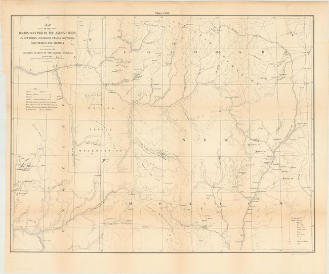
A. Map of the Region Occupied by the Ancient Ruins in Southern Colorado, Utah & Northern New Mexico and Arizona..., by George Wheeler, circa 1876 (24.5 x 19.1"). This map is from Hayden's monumental survey effort. It was prepared to accompany W.H. Holmes' report and details the Four Corners region of New Mexico, Arizona, Utah, and Colorado. It extends from the New Mexican pueblos of Taos, Santa Clara, San Ildefonso, Zuni and Laguna, west to show the Hopi Mesas, here referred to as Moqui, as well as many ancient sites including Chaco (a side bar names eleven distinct ruins), Canon de Chelly, and Mesa Verde. Good topographical and watershed detail, and numerous forts are identified. The map was the result of a thorough investigation of the area in the early days of archeological research and it would form the starting point for subsequent and more detailed examinations of specific ruins in the years to come. The Navajo reservation is shown, in a much smaller configuration than today, between Chaco and the Moqui Pueblos. Condition: Light toning with a 1" edge tear at left that has been closed on verso with archival tape. (B+)
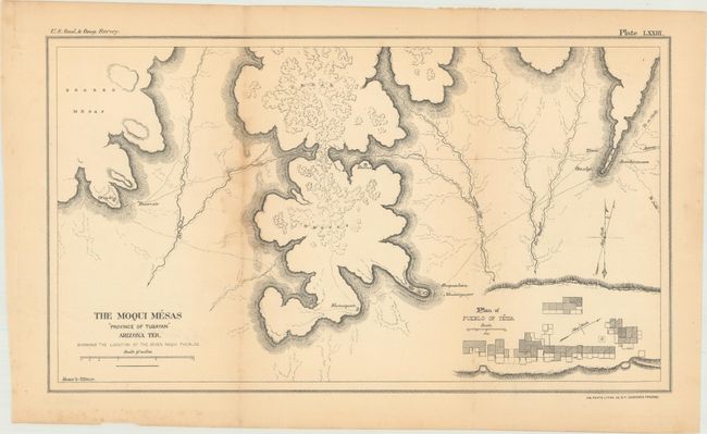
B. The Moqui Mesas "Province of Tusayan" Arizona Ter, Showing the Location of the Seven Moqui Pueblos, by Thomas Donaldson, circa 1893 (13.1 x 7.5"). This map was included in the Extra Census Bulletin. Moqui Pueblo Indians of Arizona and Pueblo Indians of New Mexico to accompany the Eleventh Census on the United States. It shows the Hopi Mesas in the northeastern part of the state with a series of foot trails linking the seven pueblos together. Includes a small plan of Tewa at lower right. Condition: Light staining along the left fold. (B+)
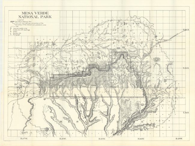
C. Mesa Verde National Park, by Eckert Litho. Co., circa 1910 (28.7 x 20.9"). This an early lithographed map details Mesa Verde Park in southwest Colorado, now known as Mesa Verde National Park. The map is filled with details including important pueblo ruins, Pueblo-like cliff dwellings, pictographs, trails and more. The terrain is depicted with hachure and the watershed is well shown. The major ruins that are today in the monument are here shown in the Southern Ute Indian Reservation, but a five mile limit line indicates that the ruins are under the jurisdiction of the Secretary of the Interior. Important ruins are Mug House, Step House, Long House, Spring House, Spruce Tree House, Balcony House and Cliff Palace. Mesa Verde contains the best preserved Indian pueblos in North America, including its Cliff Palace, considered as one of the best examples of early Indian dwellings.
The first Europeans to reach the area were Spanish explorers seeking a route from Santa Fe to California in the 1760s and 1770s. Their name for the area, Mesa Verde, meaning high, tree-covered plateau has remained to this day. In 1874 the famous photographer William Henry Jackson photographed the area and its ruins. The following year the geologist William H. Holmes retraced Jackson's route, including his findings and Jackson's photographs in the 1876 report of the Hayden Survey. Pressure on the ruins increased as settlers began to fill the nearby Mancos Valley. The continuing efforts of others, including New York newspaper reporter Virginia McClurg and the photographer and travel writer Frederick H. Chapin, to educate the public on the treasures within Mesa Verde eventually led to it becoming a National Park in 1906. Condition: Fine. (A+)
References:
Condition:
Issued folding. See description above for additional details.