Subject: Eastern United States
Period: 1827 (circa)
Publication: Carey & Lea's American Atlas
Color: Hand Color
Size:
21.1 x 16.9 inches
53.6 x 42.9 cm
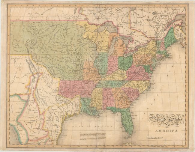
This map of the United States extends west to the Rocky Mountains and provides a detailed view of the region based on information from the expeditions of Lewis & Clark and Pike. A notation at the western edge of the map shows where "Clarks Canoes stop 3000 miles from the Mississippi." The Missouri Territory takes in the entire northern plains region from the Mississippi to the Rocky Mountains. The new state of Missouri is presented with preliminary boundaries and Arkansas is shown at its largest extent. Today's Minnesota and Wisconsin are here a part of North West Territory. In Texas there are a few place names including Ft. Matagorda, but Galveston is poorly located. Texas and the Southwest are a part of Mexico. One of the most interesting features of the map is the river system in the West, near the Highest Peak, where the headwaters of several major rivers all originate within a few miles of one another - Red River of California (Colorado), Multnomah (Willamette), Rio del Norte (Rio Grande), Arkansaw (Arkansas), and the Platte. This edition includes a notation in the Gulf of Mexico explaining the sources of the map and noting that recent surveys made by Major Long have been incorporated where "the mistakes were very palpable." Engraved by Benjamin Tanner.
References: cf. Wheat (TMW) #338; Phillips (A) #1177.
Condition: B
Lightly toned with some minor offsetting and small damp stains. There are several repairs along the centerfold including some minor paper restoration. Portions of the margins have been reinforced with tissue on the face of the sheet, affecting only the margins.