Subject: Pacific Islands
Period: 1774-85 (circa)
Publication:
Color: Black & White
Captain James Cook (1728-1779) is best known for his three voyages to the Pacific (1768-71; 1772-75; and 1776-79). His discoveries radically changed the western understanding of the world in the late 18th century. He was the first to circumnavigate and chart New Zealand and provided the earliest European accounts of exploration along the eastern coast of Australia and the Hawaiian Islands. On February 14th, 1779, he was killed on Hawaii after attempting to kidnap the chief of the island.
Many contemporary accounts of Cook’s voyages, including charts and engravings, appeared in the late 18th century. The first official account of Cook’s first voyage was published in 1773 by John Hawkesworth in Volumes II and III of An Account of the Voyages Undertaken by the Order of His Present Majesty for Making Discoveries in the Southern Hemisphere... William Strahan and Thomas Cadell published the first official accounts of the second and third voyages in 1777 and 1784. Accounts of his exploration were subsequently translated into French, German, and Dutch.
A. Carte des Isles de la Societe Decouvertes par le Lieutt. J. Cook. 1769, from Relation des Voyages Entrepris par Ordre de sa Majeste Britannique..., circa 1774 (17.1 x 11.4"). The Society Islands are a group of islands in the South Pacific Ocean, the best known being Tahiti. Some believe the archipelago was named by Captain James Cook in honor of the Royal Society, the sponsor of the scientific survey of the islands; however, in his journal Cook says he called the islands Society "as they lay contiguous to one another." This chart shows Bora-Bora, Tahaa, and Raiatea in great detail including their surrounding reefs. Also shows Big and Little Hauhine, here incorrectly shown as one island. Drawn from Cook's first Pacific voyage. Condition: Issued folding on watermarked paper with minor toning and faint offsetting. There are remnants of hinge tape on verso.
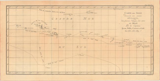
B. Carte des Isles Decouvertes aux Environs d'Otahiti, dans Plusieurs Voyages Faits Autour du Monde par les Capitaines Byron, Wallis, Carteret et Cook. En 1765. 1767. 1769, from Relation des Voyages Entrepris par Ordre de sa Majeste Britannique..., circa 1774 (20.2 x 9.4"). This chart depicts the Society Islands, including Tahiti, and the tracks of Commodore Byron, Capt. Cook, Capt. Carteret, and Capt. Wallis. It was drawn on a Mercator projection and engraved by Benard for the Paris edition of John Hawkesworth's Account of the Voyages. Condition: Issued folding on a toned watermarked sheet with minor offsetting.
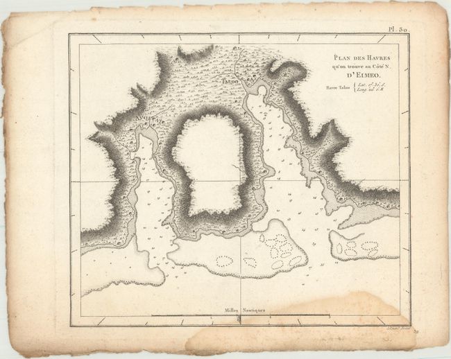
C. Plan des Havres qu'on Trouve au Cote N. d'Eimeo, from Troisieme Voyage De Cook, ou Voyage a l'Ocean Pacifique..., circa 1785 (8.7 x 7.5"). This chart zooms in on a harbor on Mo'orea Island, one of the Windward Islands of the Society Islands, near Tahiti. It shows soundings, hazards, and an anchorage, and it features excellent topographical detail and little huts along the coast. Ref: Shirley (BL Atlases) G.COOK-4a #9. Condition: A sharp impression on a watermarked sheet with a light damp stain that enters map image at bottom. There are some binding holes that are confined to the blank margin at top.
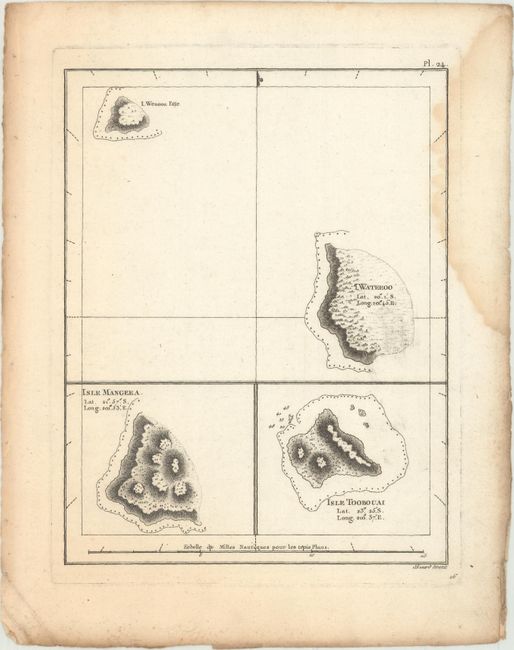
D. [I. Wenooa Ette/ I. Wateeoo/ Isle Mangeea/ Isle Toobouai], (6.8 x 8.7"). This small and handsome sheet includes three small charts, featuring three Cook Islands-- Takutea (I. Wenooa Ette, Atiu ( I. Wateeoo), and Mangaia (Isle Mangeea)-- and Tubuai (Isle Toobouai) from the Austral Islands in French Polynesia. Each chart feature nice topographical detail and some navigational information. Ref: Shirley (BL Atlases) G.COOK-4a #8. Condition: A dark impression on a watermarked sheet with a light damp stain that enters map image at right. There are binding holes in the left blank margin.
References:
Condition: B+
See description above.