Subject: Minnesota
Period: 1874 (dated)
Publication: Illustrated Historical Atlas of the State of Minnesota
Color: Hand Color
Size:
17.3 x 24.4 inches
43.9 x 62 cm
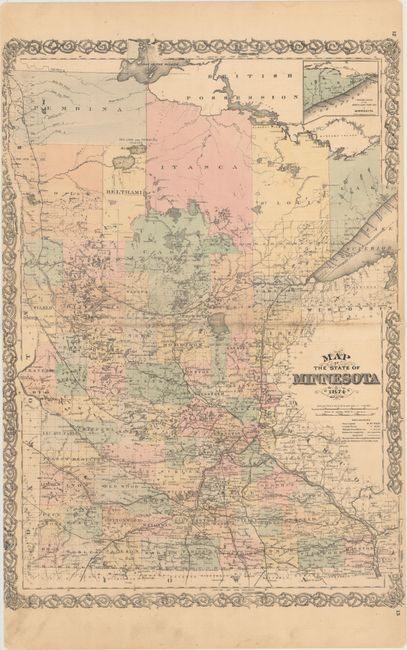
This detailed map of the state comes from Alfred T. Andreas' landmark Minnesota atlas. The map shows counties, towns and cities, and railroads, both completed and projected. County development is current to 1873, with Cottonwood, Lincoln, Todd, and Lac qui Parle, but no Cook County. There is little settlement in the northern reaches of the state.
A.T. Andreas' atlas was sold by subscription to prominent landowners throughout the state. He chose Minnesota because the state was young, the population was affluent, and the eastern mapmakers had not yet worked the area. He brought together the production facilities in Chicago, canvassers to sell subscriptions, surveyors to create plat maps, writers to produce the written materials, and artists to draw portraits and illustrations of cities and farms. The result was a comprehensive and intimate portrait of the state and is a wealth of historical information today.
References: Phillips (Atlases) #2007; Ristow, pp. 433-439.
Condition: B+
Original color with centerfold separations that enter 1" into the image on each side. There is light toning along the centerfold, a few spots of foxing, and several short edge tears into the left decorative border.